Notice:
The advice given on this site is based upon individual or quoted experience, yours may differ.
The Officers, Staff and members of this site only provide information based upon the concept that anyone utilizing this information does so at their own risk and holds harmless all contributors to this site.
I had been looking at the 441S on Amazon for $499 yesterday, and I thought too much for now. Have to wait. Then I got notice of this today. With the $200 Rebate through July 4th. http://www.megagps.com/g2vision.aspx Any suggestions? Should this be a good deal or look for something else? The 421s with a transducer sure looks tempting for $229. <b>If I got one of these, would I still need to get my Data Marine S200DL Depth meter repaired (readout is faded out)?</b> Garmin GPSMAP 441s w/transducer View Larger Image List Price: $599.99 Our Price: $319.99 After Rebate Purchase g2Vision card + this unit for $200 Mail-In-Rebate. Item Number: 010-00766-01 Quantity: * Whole number only Add to a new shopping list
Email this page to a friend
$200 GARMIN Mail-In-Rebate on sale of both this chartplotter + g2Vision card - Click this green Garmin Marine Charts button to select the correct g2Vision regions. - Click this yellow Garmin $200 Mail-In-Rebate button to read and print the rebate form. - Sale must be made between 4/7/2011 and 7/4/2011
Features Accessories Maps & Software In The Box Specifications Support
The GPSMAP 441s is a compact chartplotter that features an ultra-bright 4” QVGA color display along with an improved high-speed digital design for increased map drawing and panning speeds. It’s ready to go with an easy-to-use interface and a built-in, satellite-enhanced basemap preloaded with all U.S. coastal areas, including Alaska and Hawaii as well as detailed charts for Bermuda. The GPSMAP 441s also accepts BlueChart® g2 Vision cards for added features and functionality such as high-resolution satellite imagery, 3D views and Auto Guidance technology.
Explore the Seas
The GPSMAP 441s comes ready to go with preloaded U.S. coastal area map data. For areas outside the U.S., the GPSMAP 441s has a worldwide basemap with satellite images in place of more traditional maps. The GPSMAP 441s also comes standard with a high-sensitivity GPS receiver for superior satellite tracking and quicker acquisition times. In addition, the GPSMAP 441s can receive U.S. graphical weather data via optional GXM 51 satellite receiver/antenna. And with an SD card slot, it’s easy to add additional maps without connecting to a computer.
Add Sonar
The GPSMAP 441s, comes with a powerful sounder / sonar / fishfinder that clearly illustrates depth contours, fish targets and structure whether you’re fishing in freshwater or off the coast. The GPSMAP 441s are also NMEA 2000-certified for easy connectivity with sensors, instruments and future marine offerings.
Add Extras with BlueChart g2 Vision
Add optional BlueChart g2 Vision SD card, you can add a whole new dimension of exceptional features to your chartplotter.
•3D Mariner’s and Fish Eye view provides you with a 3-dimensional perspective of map information, both above and below the waterline •High-resolution satellite images and aerial photographs help you orient yourself in unfamiliar areas •Auto Guidance technology searches through all relevant charts to create a route you can actually follow — one that avoids obstacles, shallow water, buoys and other obstructions
• Ultra-bright 4” diagonal QVGA display, 240 x 320 pixels – over 800 nits of brightness • NMEA 2000 certified for seamless integration with the Garmin marine lineup • Preloaded worldwide marine basemap • Compatible with GXM 51 for XM Satellite Radio and XM WX Satellite Weather • Built-in high-sensitivity GPS receiver • High-speed processor for fast screen redraws and smooth panning • Streamlined user interface makes it simple to select modes and features • Single SD memory card slot for BlueChart g2 Vision cards, as well as saving waypoints, routes and tracks to a SD card • Adding optional BlueChart g2 Vision cards provide enhanced navigation features like Auto Guidance, satellite imagery, 3-D Mariner’s Eye View and 3-D Fish Eye View • Backlit keypad for easy operation in low light conditions • Unit dimensions: 5.0”H x 5.7”W x 2.7”D (12.7cm H x 14.5cm W x 6.9cm D) Power output: 500 watts (RMS) 4000 watts (peak to peak), dual frequency • Depth: 1,500 feet / 500 meters (dual frequency) • Use a dual frequency transducer 50kHz (45°), 200kHz (10°) for maximum saltwater performance • Patented transom/trolling mount transducer • UltraScroll™ high rep rate sonar provides lightning-fast screen updates • AutoGain technology enhances target visibility • See-Thru® technology: shows weak and strong returns simultaneously • Water temperature log graphically records water temp data • A-scope • Whiteline • Adjustable depth line helps gauge desired fishing levels and bottom clearance • Split zoom display offers a closer look at fish targets and bottom structure • 2X, 4X and bottomlock zoom • Adjustable keel offset • Alarms for fish size, shallow water, deep water and low battery
God created the Seas as a blessing to Sailors. Doug, Jenny & First Mate Taylor, Arlington TX No. 5842 "Promise" 1989 C25, TR/WK, Inboard Diesel, 1995 Stratos 278, 115 HP Evinrude 1978 14' Dolphin Sr.
Am I dense, or is this extremely deceptive advertising?
It looks like they're advertising prices after the $200 rebate, but in order to get that rebate you need to buy a g2 Vision card for ~$269. So instead of paying $229/$319 for a 421s/441s, you actually have to pay $498/$588.
I'll let others comment whether this is an OK price. If you need inland lakes anyway, you need the card. But if you sail in coastal waters, you're buying a card that you may not need.
IMO Garmin has always had hopelessly complicated product portfolio, and this just reinforces my belief.
I HATE mail in rebates....it's a BS way for a company to trick you with fake low prices....they put up these seemingly wonderful prices, but in fact you are paying them the full price. Once you receive your product, you send in the form, UPC and receipt...then wait some 12 weeks (3 friggan months!) in some cases to get your check from Garmin for $200....and sometime you never get the check, and they claim they never received anything....and you're out.
Personally, no thanks. Retailer, take care of the rebate and sell it to me cheap. Otherwise, no deal.
Well, well, not looking so good for the home team. It appears this is not the deal of the century after all. It looks like you have to either buy the additional map or forget the rebate. There must be a better way.
I have the Garmin 541s ("s" is for sounder) and like it a lot. The 541 has a 5 inch diagonal screen vs 4 inches for the 441s. The transducer that comes with them are normally transom mounted. I opted for the in hull transducer (sold separately) and mounted it, as Catalina suggested, below the v-berth. That way, there are no additional holes in the boat, the transducer is forward of the keel giving you a little more warning, and the transducer is not subject to marine growth. I don't have the g2 vision card, so I can't comment on what, if anything it adds.
I bought mine form a company called BOE marine in Annapolis, MD. They always have very good prices on marine electronics and provide free shipping on many items. I have bought marine and automotive GPSs from them as well as trim tabs for my prior power boat. I have always been satisfied with their customer service and prices. http://www.boemarine.com/ BOE usually sells Garmin units with or without transducers and they sell in-hull transducers separately.
FWIW, I really like my Garmin 640--coastal charts, street maps, boat navigation, car navigation (voice ala Nuvi), mounts for both, fairly large touch screen, built-in battery (can go anywhere)... WM occasionally has it for $800, which is the lowest I've seen anywhere. (Now there's a surprise!)
<blockquote id="quote"><font size="1" face="Verdana, Arial, Helvetica" id="quote">quote:<hr height="1" noshade id="quote"><i>Originally posted by Stinkpotter</i> <br />FWIW, I really like my Garmin 640--coastal charts, street maps, boat navigation, car navigation (voice ala Nuvi), mounts for both, fairly large touch screen, built-in battery (can go anywhere)... WM occasionally has it for $800, which is the lowest I've seen anywhere. (Now there's a surprise!) <hr height="1" noshade id="quote"></font id="quote"></blockquote id="quote"> The discounted price should be coming down even more in the near future. Garmin sent me this email 10 days ago:
GPSMAP® 640 Price Reductions GPSMAP 640
We just reduced the MSRP for GPSMAP 640. It's now only $799.99. This full-featured plotter gives you the flexibility to navigate by land and water. A great convenience if you trailer your boat – preloaded with City Nav data for use driving and then it moves easily to your boat with preloaded BlueChart data. The GPSMAP 620 is also reduced to just $699.99.
...so there should be prices in the 6s soon. Doesn't hurt my feelings--I've had mine for a year and a half--$800 from WM. I should mention I think the battery is a real plus--that's not in their regular marine plotters.
<blockquote id="quote"><font size="1" face="Verdana, Arial, Helvetica" id="quote">quote:<hr height="1" noshade id="quote"><i>Originally posted by Stinkpotter</i> <br />...so there should be prices in the 6s soon. Doesn't hurt my feelings--I've had mine for a year and a half--$800 from WM. I should mention I think the battery is a real plus--that's not in their regular marine plotters. <hr height="1" noshade id="quote"></font id="quote"></blockquote id="quote"> Oh, I wasn't trying to hurt anyone's feelings - just tip people off to wait a bit if the lower prices haven't trickled down yet.
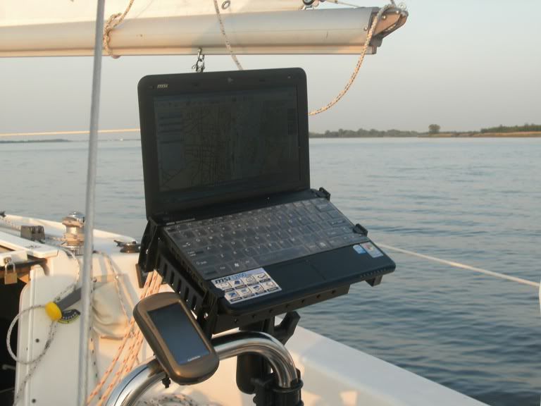
You may recall from a prior post that I had bought the 640 for $720 last November, but returned it to go with a laptop chartplotter instead. No regrets here either, though everyone's needs are different. I only go out in fair weather conditions, so don't need a waterproof system. And I like getting the GPS and AIS totally wirelessly with no cables attached (see latest Mainsheet for details):
At this time I'm using a Garmin GPSMAP 378 with the XM Satelitte Weather add on and it works great. It wasn't cheap but it's nice to see the thunderstorms coming in advance and the direction they are moving laid over my present position.
The biggest problem I have is I have to pick it up and look at it up close when I don't have my glasses on. I'd like to have a larger display that I could see and read form a distance.
Rick -- You have the setup I've been looking for! Didn't you post some details in another post somewhere? I can't find it but would be interested in building this system.
I recently purchased a Motorola Zoom and will be trying it out tomorrow when I go out. Big screen, can be easily slid into a waterproof sleeve (ie: 1 gallon Zip-Lock bag), and has built in GPS.
I'd like to find a nice mount for it but haven't located one yet.
Notice: The advice given on this site is based upon individual or quoted experience, yours may differ. The Officers, Staff and members of this site only provide information based upon the concept that anyone utilizing this information does so at their own risk and holds harmless all contributors to this site.