Notice:
The advice given on this site is based upon individual or quoted experience, yours may differ.
The Officers, Staff and members of this site only provide information based upon the concept that anyone utilizing this information does so at their own risk and holds harmless all contributors to this site.
I just brought home my 1998 250 WK it's on the trailer and I have a bit of a to do list before she goes in the water (bottom paint etc.)Any suggestions on what brand of depth finder to use? Or more importantly where to place the transducer. Should I do a transom mount or use a transducer that will transmit and receive through the hull. Where is a good place to mount a through the hull transducer. I have a tiller where is a good place to mount the display in the cockpit? I appreciate any thoughts.
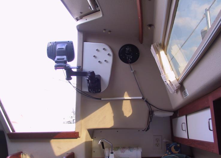
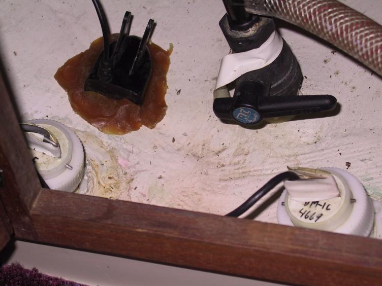
Hi Johnnybob, I'd go with a fishfinder/chartplotter and a through hull as close to the bow as possible. I have the C-25 so not sure where that is on the C-250. To do the through hull you use toilet seating wax (it's a mess!). Clean the piece of hull you put it on, make sure there's no air pockets and press the transducer into it. You can spend a little or a lot on your fishfinder or chartplotter, it depends on what you plan on doing with your boat. I mounted mine on a swingarm inside the companionway on the starboard side.
What Daver said. Many threads in the past have come to the same conclusion. Hard to beat the price and functionality of a cheap fishfinder. PLus it finds fish!
My boat had a depthsounder installed when we got it. It's only depth, not a fish finder. The unit is a Raymarine ST40, uses a thru hull (hole in the hull), display is mounted on the bulkhead next to the companionway. Unit works great, no problems. The thru hull is mounted right under the V-berth access boards, about 19 inches in front of the seat riser, just in front of the fresh water tank (roughly 30 inches in front of the keel).
Just purchased a Raymarine ST40 knot meter, will install it one of these weekends. The installation instructions say to not put the speed transducer thru hull in front of the depth sounder transducer, as the turbulence from the speed transducer may affect the depth sounder readings. Looks like I'll have to move the water tank forward a bit, and install this transducer just in front of the seat riser. I'm planning to install an access port in the seat riser to get to it.
We also have the Raymarine speed and depth. They are mounted side by side one on each side of the centerline just in friont of the water tank in the V berth. Probably 6 inches between them. They both work great.
Our display is on the starboard bulkhead below the cabin top winch and to the right of the sheet bag.
We have a Garmin 541S chartplotter/sounder combination on our C250WK. The transducer is an airmar P79 in hull, mounted under the v-berth in front of the keel. It is mounted slightly starboard of the centerline and the P79 adjusts for V in the bottom. We usually use the Garmin on the chartplotter page where it displays US coatal charts, GPS boat speed in knots (or mph if desired), and water depth. Change the page and it becomes a fishfinder, or split the screen to display both simultaneously. You can optionally add XM weather and radio if desired. It really works great and there are no holes in the bottom of the boat.
One additional point. With a in hull transducer there are no growth or corrosion issues as the transducer never comes in contact with raw water. Also, there is nothing outside the hull to damage while trailering or launching.
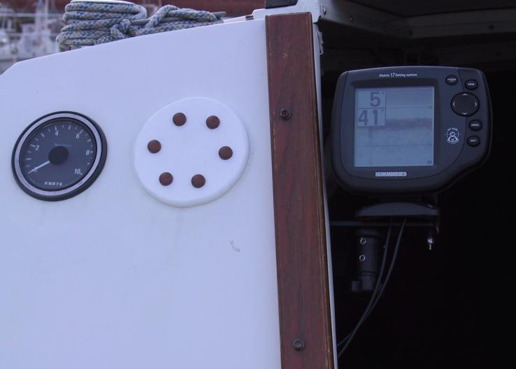
I also installed a fishfinder, usually available for under $80, and used the wax ring method placing the transducer against ther hull just aft of the swing keel trunk (puts it below the companionway). It shoots a wide enough range to give me plenty of warning about skinny water:
It's easily removable, there's a bracket on the companionway wood with a pair of washers for spacers that the angle brace slides into:
Which sounder depends a little on whether you anchor out. A fish finder/sounder has some advantage because after a little experience, it will indicate the bottom structure and aid in the anchor choice if you carry more than one type of anchor.
<blockquote id="quote"><font size="1" face="Verdana, Arial, Helvetica" id="quote">quote:<hr height="1" noshade id="quote"><i>Originally posted by Arlyn Stewart</i> <br />Which sounder depends a little on whether you anchor out. A fish finder/sounder has some advantage because after a little experience, it will indicate the bottom structure and aid in the anchor choice if you carry more than one type of anchor. <hr height="1" noshade id="quote"></font id="quote"></blockquote id="quote"> Arlyn, I have been struggling with this issue re GPS, chartplotter, fishfinder, combo, sonar, yada, yada, yada. I have a handheld and my Iphone with Navionices. I am really wanting something for anchoring. So the best shallow water device indicating the bottom structure as you mentioned, would be ideal. Here is the rundown for our members: I have looked fish finders, the Garmin Fish finder 140 w/ a 5" screen is great at $90 but this and others with a in hull transducer have a limited view, like 12-15 degrees. Only the transom/trolling motor mount have dual beam transducers which have both narrow and wide-45 degree view. The next step and really best solution, is the chart-plotter sounder units. The Dual beam transducers for in hull are available. I like Garmin 441s($449 on sale w/o $100+ transducer) and it $100 off at WM but the information, Depth, etc is too small for me to read. I would need to step up to probably and 5" or better yet a 7" screen. But boy the prices really jump. Its kinda hard for me to justify especially since I just ordered a new sail. Well I was warned what b-o-a-t really means! Break Out Another Thousand- for you newbies. Guess I will wait till they go on sale. Until then I will use my mask and snorkel. Steve A
I purchased the Garmin GPSMAP sounder - 531S, I believe. It works beautifully and the toilet wax used to mount the in-hull transducer just under the v-berth is still just fine. I get great readings and in sunlight the screen is VERY clear.
With only a couple of days left on the Great Lakes summer cruise, we were working our way home and late in the day reached the intended bay for the planned evening anchorage. The bay was large enough that winds could kick it up so it required choosing a lee area. Unfortunately, by the time we'd arrived winds had shifted out of the North and intensified with forecast of increasing intensity.
While the bay lies to the South, a good size Island guards its Northern exposure with channels in and out of the bay at each end of the Island. We'd have to lie in the lee of the Island but had never used such a position previous. Several attempts were made to set the anchor but it would not take. The sounder showed a hard bottom, which could be seen in the clear water to be light grey in color.
I was perplexed. There were no other choices close enough to deal with the strong and building Northerly. I concluded that the light grey color had to mean a lime stone bottom and given the channels to either side, the currents forced through the channels prevented silt from accumulating. The question... could the anchor be dug into the sandstone?
I'm not a great diver and without fins am limited to about eight - ten feet but that fit where we wanted to be about eighty yards in the lee with the very gradual sloped bottom. The water was very cold, but visibility was the best I've ever seen underwater and it soon became apparent that hammering a bit with the flukes of the Danforth could break through the two inch limestone crust. The anchor was set hooking the flukes on the broken crust and then a mushroom anchor with its line was shackled around the rode and slid down to ensure a lateral pull against the crust. The only danger would be a significant wind shift would dislodge its hook on the edge... we'd have to be wary.
Before dark, a power cruiser and another sailboat tried to take shelter as we'd done but neither were successful in a position near enough to the island to prevent a rough night. Both drug their anchors to a point well South of the island where the currents between the channels evidently didn't come into play to prevent a silt bottom.
We didn't have the luxury of simply having a rough night as among the crew was our Sheltie lass who needed to get ashore for her duties. The eighty yard row into the wind was all I could do. I'd never made it from the two hundred yard leeward positions taken by the other two boats.
I have my garmin mounted on the port bulkhead using an adhesive mount ball/ram mount. I then also have another ball mount on the head wall. This allows me to easily move the garmin in and out of the cockpit.
Notice: The advice given on this site is based upon individual or quoted experience, yours may differ. The Officers, Staff and members of this site only provide information based upon the concept that anyone utilizing this information does so at their own risk and holds harmless all contributors to this site.