|
|
|
|
|
|
|
|
|
|
|
|
|
|
|
|
|
|
|
|
|
|
|
|
|
|
|
|
|
|
|
|
|
|
|
|
|
|
|
|
|
|
|
|
|
|
|
|
|

Halo Around the Sacred Isle
Part 3: Days Five and Six
By Arlyn Stewart
 DAY
FIVE
DAY
FIVE
Browning Cove, Heywood Island to The Pool, Baie Fine
8 hours (mid day excursion)
18 miles
Winds - W 10-12
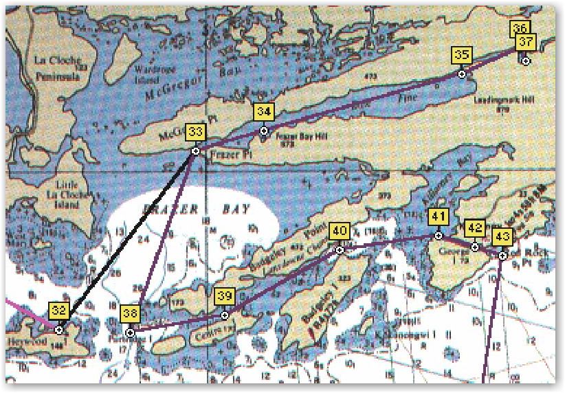
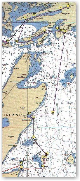
Setting a broad reach course with all sail bent, we made for Frazer Point, and the small entrance to Baie Fine a long finger like bay running east-west. We were fortunate to have wind on the aft starboard quarter. The hills on both sides would have pushed a southerly well overhead. Reaching Marianne Bay, we motored within and took the place of the boat we met exiting. Fifty feet from the bank, we raised the center board and rudder, dropped the hook, engaged reverse swinging to port around the anchor rode to a short distance from the bank where, using the dingy, a line was tied to a tree.
 With
some water and the camera we rowed the short distance to the beginning of
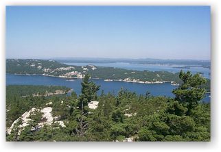
the hiking trail up Casson peak. The top is about five hundred feet and
requires about thirty minutes of rugged uphill climb. The view from the
top is an entirely different perspective to that below. In some ways it is
like looking at three-dimensional charts as the different water leads and
islands can be identified. On the top is a plaque imbedded in a rock that
indicates the last resting place of the ashes of one who greatly loved
this view. Pictures were taken and a nice visit was had with a cruising
family from near Toronto.
With
some water and the camera we rowed the short distance to the beginning of
the hiking trail up Casson peak. The top is about five hundred feet and
requires about thirty minutes of rugged uphill climb. The view from the
top is an entirely different perspective to that below. In some ways it is
like looking at three-dimensional charts as the different water leads and
islands can be identified. On the top is a plaque imbedded in a rock that
indicates the last resting place of the ashes of one who greatly loved
this view. Pictures were taken and a nice visit was had with a cruising
family from near Toronto.
Continuing
into Baie Fine, we were given our only opportunity on the c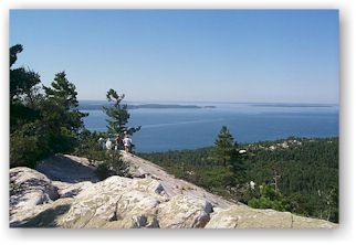 ruise to fly
the drifter. It pushed us up the narrow bay at 5 mph while pulling away
from the boat astern and gaining on the boat ahead. We doused near the end
of the bay as it requires navigating a narrow entry into the second or
inner bay that again runs east and west. This inner bay was just beyond
the cutoff of our chart so not realizing how far it was to the end we were
quite surprised that another several miles were required to reach The Pool
at the end. At the end of this bay, a ninety-degree starboard turn leads
into The Pool, a picturesque bay surrounded by rock and pine trees.
ruise to fly
the drifter. It pushed us up the narrow bay at 5 mph while pulling away
from the boat astern and gaining on the boat ahead. We doused near the end
of the bay as it requires navigating a narrow entry into the second or
inner bay that again runs east and west. This inner bay was just beyond
the cutoff of our chart so not realizing how far it was to the end we were
quite surprised that another several miles were required to reach The Pool
at the end. At the end of this bay, a ninety-degree starboard turn leads
into The Pool, a picturesque bay surrounded by rock and pine trees.
Visiting with an old timer later that afternoon revealed that just as our native Michigan had been cleared of the majestic white pine, so had this country been covered by the majestic white pine. The logging here was done in the twentieth century where Michigan had been logged in the 1800’s. He described a log slew across the bay and the use of teams in the operation.
The Pool, famous for several pieces of artwork inspired by it, would have been and was for many years a favorite anchorage for any one cruising in the area. Popularity has greatly waned as the result of weed growth that fouls motor and anchor. My gps sounder unit includes a fish finder which when we changed modes, showed the bottom in some places being more than fifteen feet deep with weed that came to the surface. The weed areas can be seen on the surface and carefully motoring around we found an anchorage without weed. It was warm so an afternoon swim felt good. Late in the afternoon we took the dingy over to another hiking trail leading to an interior lake. It was here that we visited with the old timer who was resting in a chair while waiting on his son bringing out a group of campers from the inner lake. He estimated that they would be coming shortly down the trail on an ATV pulling a trailer loaded with supplies. We started up the trail and shortly met the outbound campers and gear. The gear rode but the campers walked. The trail was not as rugged as the earlier one, but it was much longer with about 2 ˝ miles to the crest and 1 mile down to the lake. When reaching the lake we were surprised to see some houses on the North shore but remembered a comment from our earlier guide back at Browning Cove that described the lake as being the northern boundary of the park that extends from Killarney.
While returning we meet three young couples coming onto the main trail from a side trail to a small lake that is popular for swimming. We wonder if it would have been entertaining if we had chosen it as our destination. Their hair was wet, and they weren’t carrying any towel bags.
Preparing to board the dingy, I feel a sharp pain in my foot and realize a small resistance as I lift my foot. Standing an inch or more above the sand is a square nail that is lodged into some boards that are part of an old dock. It has punctured thru my shoe and I feel the sticky ooze quickly within my sock. Knowing that it has bled some, I decide to wait till were back at the boat to inspect. A rock bends the nail flat so it wouldn’t claim another victim. Returning to the boat, with the evening sun low, we didn’t see one of the weed beds and motored into it, stopping within ten feet. Killing and raising the motor, it is completely fouled with weed. Each taking a paddle we skull our way off the weeds, clear the motor and carefully return to the boat. There I remove the shoe, the bloodied sock and squeeze a bit more, then clean with an alcohol swab. I decide that I should probably forego any further swimming for a few days. Almost two months later as I write, the outward three toes on this foot are recovering from numbness. Not the sleepy numbness from lack of blood, but the numbness from nerve damage or bruise.
Even with a sore foot, pain in my stomach from the gastritis, and a chest infection that has me coughing up green gunk from deep within, I am greatly enjoying the cruise. The weather, just as last year, has been excellent. A big difference this year has been the amount of wind that hasn’t been on the nose.
In the middle of the afternoon, a boat came into the Pool and anchored. It had a much different sounding motor than typical to most cruising yachts. We had been able to see its mast over the ridge that separated the L shaped area where we were anchored. While returning from our evening hike, we had opportunity for a close inspection of the large motor sailing craft. It was probably sixty-five feet and carried a Great Britain ensign.
The evening meal was baked beans with hot dogs chunked and thrown in. It was the only time to use the gas grill on this cruise. Our meals had been fairly simple. Breakfast was either cold cereal or oatmeal with juice and hot chocolate. Lunch was not a defined meal. Daytime eating was spontaneous and included apples, mixed nuts, snack bars, and chips with picante sauce and crackers with cheese or peanut butter. Evening meals were spaghetti, chili, beans with dogs, stew, and turkey'n cheese subs. We ate out one time the first evening out. We did enjoy a single scoop of ice cream on three occasions.
Refreshments on board were two cases of soda (24-12 oz cans), two cases of sport drink (24-16 oz bottles) and two cases of bottled water (24-1 qt bottles). Two of us consumed about half of that stock in eight days.
Supplies bought along the way were ice (two times), rolls for the subs (left at house accidentally) and cough drops so I could get relief long enough for Art to fall asleep.
 DAY
SIX
DAY
SIX
Bay Fine to Club Island
13 hours
54 miles
Winds – S at 25+ turning SW
Just before false dawn, I heard the first of the distant rumblings. By the time of first light, it had begun to rain. This prompted crawling out of the sleeping bag to install the all weather enclosure around the companionway. With it in place there is standing room in the cabin in the area of the galley and door to the head. It also provides ventilation unless the rain is heavy. Following an early breakfast, we decided to get started when most would have committed to sitting tight, but we could at least make the ten miles to the entrance of this long narrow bay. In foul weather gear, we motored toward the entrance to Bay Fine in the light rain and increased wind that the storm had brought. Sheltered within the narrow bay it was difficult to know how much. The storm had moved on with the leading edge of the front but had left a strong wind. We decided to probe out and if conditions were bad we could return a short distance within and anchor.
Conditions were rough, but under a double reefed main and half the head sail, we close hauled in moderate seas across Frazier Bay and entered the channel that ran towards Killarney. This channel separated a series of Islands that formed in a SW to NE direction. Sheltered in the lee of the islands on our starboard side we settled on a broad reach and bent all sail. Careful attention to the charts was needed. This course had not been part of last winters preplanning and it offered some shoals. Of concern as well was the possibility of heavy and confused air at points between the islands on our starboard.
I had noted that in some places the gps speed showed significant loss of boat speed down to two mph at times when I knew that the boat had been driving well and consistently at probably near six mph. When we arrived at the first navigation aids, their list and a strong swirl of water around them indicated that indeed a three to four knot current was flowing. This meant that the south wind across Georgian Bay was banking water into Killarney Bay and it was flowing down Lansdowne Channel.
Before leaving the Lansdowne channel, we would need to return to the same reefs we had prior to entering the other end. The chart showed the path across Killarney Bay required staying between a shoal off the point of Badgely Island which was on our weather side, and Badgely Rocks which ran a little further off the Island. The distance between these hazards was a quarter mile, but with a 25+ mph wind blowing from the south and a course change needed to the southeast it would mean a close hauled course for a short way. With both the currents and leeway pushing towards Badgely Rocks, it meant danger. A habit that I have developed is to prepare the motor whenever I think I might need it in a hurry. The Catalina 250 has a motor well so that instead of lowering the motor, it is tilted on its mount into the water. This requires moving a locking lever before lowering. I prepared this lever and pulled the choke out and set the throttle to the start position. My motor will almost always start on the first pull, and never needs more than two. These steps reduce the time it takes to get the motor going by two thirds, so instead of fifteen, it is less than five seconds.
When we broke from the lee of Badgely Island we were double reefed with half of the headsail as we had been when we entered. What I failed to realize was the fetch difference between the two ends of this eight-mile long channel. The western end that we had entered was in the lee of Manitoulin Island about five miles to the south. This eastern end entering Killarney Bay had a southern fetch of a hundred miles all the way down Georgian Bay. The impact was dramatic, it was blowing like stink, there was five feet of swell and there were close hazards in our lee. I looked ahead and saw the huge rocks that made up Badgely Rocks on the chart. Art was at the helm as I had done the reefing prior to leaving the channel, and I immediately called for him to come as high on the course through the hazards as he could. We had examined the chart together and both new the course needed. I firmed up the sail, and spotted the shoal marker to starboard and we pressed toward it. I urged Art to keep high but not at the cost of boat speed. I thought of starting the motor but knew that I should have done that prior to leaving the channel. Taking a second observation to decide on the motor I realized that our position and progress was good and that we were not in harms way. Sailing by the rocks 100 yrds to port, I heard Art saying something that I couldn't quite make out. I looked at him questioning his comment and he repeated the words, "damn those rocks are big", while wearing a grin that I have come to know over the years as (that was interesting). They were nasty looking and double so with the wind and current driving towards them. We continued across the bay and followed the narrow channel into the city of Killarney.
I’ve been on the rocks one time. It was many years ago during my first season with my Catamaran. On a blustery day, I had attempted to tack and went into irons. A second attempt to get speed and make the tack was also unsuccessfully and by this time leeway had taken me near the bank and against a rock. Dismounting on the windward side we pulled the bows around and sailed off but there was a small crack in the hull that damaged my ego more than it did the boat. It now looms a worthwhile learning experience that I will do my best never to repeat.
About two hours later as we sailed south in Georgian Bay, we heard a conversation on the VHF between a sailboat skipper and a marina at Killarney. He was sailing East in the Lansdowne Channel as we had. His motor wouldn’t run and he was asking for a tow up the narrow Killarney Channel after he crossed Killarney Bay. The marina staff said, stand by, I think you need to talk to the owner. When the marina owner got to the radio he asked the captain where he was. The captain reported that he was passing the gravel works not too far from the east end of Badgely Island and hoped to get a tow after crossing the bay. The marina owner said, standby for a moment. When he returned to the radio, he said, that after conferring with his staff, they were convinced that the captain ought to remain in the Lansdowne Channel and wait for the marina boat that would leave immediately. They would do what they could to start the engine or consider towing, but that they strongly recommended not leaving Lansdowne channel and entering Killarney Bay without power in the conditions that existed. I looked at Art and said, "I heard that!" Art’s reply, "hope he takes the advice." The captain radioed back that he was preparing to anchor in the channel and would wait there. I was relieved; I would have worried that he might have come out of the channel with too much sail or not stayed high enough to the windward mark.
It was about 10:30 am when we motored through the Killarney Channel. First order of business was to take care of the boat; she needed gas, a pump out, fresh water, and ice. I needed some cough drops. Every place seemed crowded with boats. Towards the eastern end and on the mainland side was a store with space at its docks. After tying up, we fueled, watered, iced and got the cough drops but we would have to get into one of the marinas for the pump out. They were all very busy. The current we had seen in the Lansdowne channel had also plagued this city channel last night. Two of the marinas had suffered damage to their docks and were shuffling boats around to clear the outer slips. Many boaters had sought refuge from the wind conditions. With many large craft in the outside slips, the current had exerted more force than the docks had previously been subjected to. Staff were busy relocating boats out of the outer slips. In the hour or so we spent at Killarney, there were probably ten boats that hailed marinas attempting to find accommodations. One captain, instead of going through the list of marinas, simply inquired if there was any one in the area who could provide him a slip, and finished with the comment that "cost was not a problem." He received no answer.
I crawled deep into the aft berth with a flashlight and took a look at the holding tank. Three quarters full meant one quarter empty so we decided to avoid the fray for attention from the marinas and either find an anchorage or continue on.
While undoing the dock lines and preparing to leave, I heard the sound of an approaching airplane and looked east up the channel to see a low wing prop plane flying low toward us, directly down the channel. He buzzed us at 150 feet at full throttle with the strong south wind coming over George Island buffeting the plane around like a kite. He was either a very good pilot, very crazy pilot or both. I couldn’t tell in the flash of speed what plane it was, but a high pitch whine indicated the engine might have been supercharged. Within a minute, he came back at the same altitude and speed, bouncing his way down the channel. I have seen mustangs and corsairs at high speed and this airplane wasn’t going much slower than they. For a prop plane, it was fast. Then I remembered the conversation a few days before with the customs lady at Meldrum Bay. She had related that she had been busy with processing several flyers that weather had forced to make landings at a nearby airport. They had been in route to the Oshkosh air show but nasty weather over Michigan ahead had them taking precautions. I concluded it possible that this barnstormer was returning from the air show and that Canada allows a few more liberties than the states.
Looking at the chart for an anchorage, it appeared that we might find one in the lee of George Island toward the eastern end of the channel but if the winds clocked from the west as promised later in the afternoon, the anchorage would be poor. Our destination was either Club Island or Rattlesnake Harbor on Fitzwilliam Island. They were many miles to the south and we had no desire to motor into a 25-mph wind on the bow in 4’ swell. The day was still young however and we studied the chart for another possibility. If we were game for a wild ride, we could beat towards Smith Bay on Manitoulin Island fifteen miles to the southwest. The last five miles would be in the lee and would settle down. We could take anchorage in the deep bay and be well protected.
Other than strong winds, there were no other forecast problems. If the wind shifted we would take advantage and head south toward our intended destination. Deciding to venture out, we rounded Northeast Point and hoisted the yet double-reefed main and half the jib. We took turns getting our foul weather gear on and I included my sea boots as the open transom occasionally flooded with cold water. The rain in the morning had been light, and I recalled that the forward hatch hadn’t been dogged down properly. Preparing to raise the anchor, Art had stumbled onto the forward hatch as I was about to dog it down and my fingers got pinched. Art went to dog it down and reported that our sleeping bags were a little wet, from deck wash entering the unsealed hatch. I thought back to entering Killarney Bay with out the hatch dogged and realized it was poor seamanship to have forgotten it. The dogs usually latch and the hatch probably wouldn’t have come open, but it also doesn’t seal until pulled down tight.
The ride was as expected, wet and wild. The C250 has a lot of freeboard and stays pretty dry but last years experience had taught me that with wave action of 5-6 feet, rogues will wash the deck. The first hour or so we beat into a strong 25 + wind. As the afternoon wore on, the wind abated. Approaching Cape Smith it was time for a decision. Enter Smith Bay or beat south. It was a beautiful afternoon. The wind had settled down to a comfortable 15 mph under clear skies. We now had all sail up and the boat was moving well. Our sleeping bags needed drying out and the wind would now allow them to be brought on deck.
The wind was shifting west about five degrees per hour which favored our progress south. Since Cape Smith we had sailed southeast on a starboard tack and now stood out from Manitoulin Island many miles east. It was now evident that the wind would not shift enough and we would need a port tack to make the anchorage at Club Island. One option was to stay this course until a port tack would fetch James Bay. James Bay was a possible evening anchorage, though reports suggest it is not an ideal one. If it was not suitable, then we could fetch Club Island back on a starboard tack.
We sailed into the bay, noted the incoming swell and tacked back on starboard and headed SSE towards Club Island. With the wind promised to shift to the west it appeared that our choice of Club Harbor over Rattlesnake Harbor would be the better of the two choices.
Because it was getting late in the evening, I put some Chili on the stove to heat while underway and we enjoyed eating in the cockpit while the auto pilot steered the course to Club island. Our sleeping bags had completely dried in the afternoon sun and wind. After the initial heavy winds and sea conditions, the majority of the passage from Killarney to Club Island had been a wonderful sail in ideal weather conditions even though most of it was on a beat. We had been able to cover a lot of water while beating however and this was encouraging. It seems that if conditions slack off enough to get full main aloft, good progress can be made.
If we had stayed in James Bay, the shift of wind may have made the anchorage more enjoyable and we would have been alone. The decision to move on turned out to be a bad one.
When we turned the NE corner of Club Island, a sailboat was approaching Club Harbor from the south and was just ahead of us at the entrance. We slowed our pace to give the other boat the freedom to pick their anchorage without being pressured. When they were swinging on anchor we took a spot in the next largest open area. The water was clear and we had made our way to about eight feet of depth. The bottom was rocky and the danforth did not bite in two attempts so the bruce was pulled out of the cockpit locker. I decided to lay both to keep the boat from sailing on the anchor. This anchorage was very sheltered to the surf but the island wasn’t very big and did not block the steady wind. The evening meal having been eaten while under way, we enjoyed a lazy sunset in the cockpit discussing the merits and implications of GPS navigation and the use of chart plotting.
The approach to Club Harbor had offered extra time because of the boat ahead of us. I had chosen to turn on the computer and check the plot of the boat on the chart. Two things that I wanted to observe was the changing of the chart when we reached the boundary of the harbor chart and the relation of the moving mark on the chart to what our visual observations showed. The results were that it was apparent that we could have sailed into this harbor and dropped anchor in thick fog by piloting with the moving fix of the gps as plotted on the screen. Of course, we would have had to deal with other boats. The chart change was completed automatically and took only a second or two. The plot on the moving map very closely represented where our visual observations placed us as we entered the harbor entrance, and positioned for anchoring. This test was also a very good witness to: 1) that the chart was well done, 2) that OziExplorer program was doing a good job, and 3) that the calibration routine and efforts had been done well.
Day six was slow to end however. As mentioned, this harbor was open to the wind, and a neighbor boat had a halyard that was slapping. While some salty sailors might enjoy the rhythm and tone and atmosphere that a slapping halyard offers, this sailor does not. If there are indications of lack of seamanship, a slapping halyard has to be high on the list. It further indicates a lack of sensitivity, and consideration for others. I’m saying this halyard slapped all night long and ruined what should have been a very peaceful rest for the crews of the six other vessels sharing the anchorage. By the time we had reached Club Island, the wind had shifted completely to the west. James Bay would have been suitable and we would have been alone. You cannot imagine how many times during the night that I wished we had stayed.
Arlyn Stewart
C250 w/b "R&R"
Submitted: October 22, 1999