|
|
|
|
|
|
|
|
|
|
|
|
|
|
|
|
|
|
|
|
|
|
|
|
|
|
|
|
|
|
|
|
|
|
|
|
|
|
|
|
|
|
|
|
|
|
|
|
|

Halo Around the Sacred Isle
Part 4: Days Seven and Eight
By Arlyn Stewart
 DAY
SEVEN
DAY
SEVEN
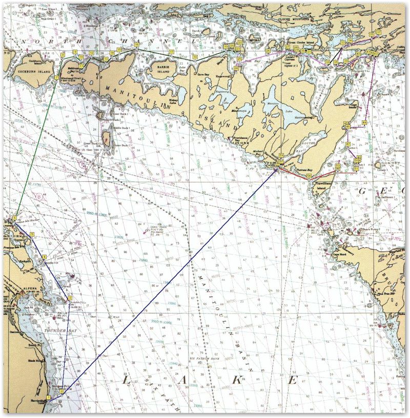
Club Island to South Bay
7 ˝ hours
25 Miles
Winds – 15 building to 25 from NW
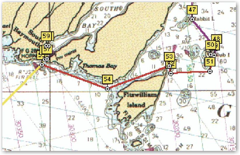
Club Island was a nice anchorage except for the slapping halyard on the neighbor boat. They motored from the anchorage ahead of us. We sailed off and both made a starboard turn south. We stood closer to the island as the charts showed good depth and we planned a west course when clearing the shoals of the southern end. I am not sure if the other boat was wanting us to take the lead of a probably course to the Bruce Peninsula or why they reversed their course for a few minutes and sailed back north. When we were ahead, they reversed course again to the south. Clearing the shoals we came around to a close-hauled course west towards the NE point of Fitzwilliam Island. Fortune was on our side as the course was attainable without a need to pinch and the sail between the two islands was enjoyable in the clear cool morning air. The wind had blown all night and was consistent in velocity and direction. Our actual course would take us just south of the NE point.
 The
ridgeline of Fitzwilliam Island extends NE. This ridge surfaces again off
the NE point in an Island called Wall Island. The shallow area between
these islands is Wall Island Channel. There are shoals in this channel two
feet below datum. If we were not careful we could ground the centerboard
or rudder. There were also no navigation aids marking these shallows, as
traffic would be expected to clear wall Island to the north. . When
planning the cruise, I had noted this shallow channel and thought that the
challenge of navigating through it would be interesting. With out gps or
depth indicator it would not have been wise to attempt it in the absence
of navigation aids.
The
ridgeline of Fitzwilliam Island extends NE. This ridge surfaces again off
the NE point in an Island called Wall Island. The shallow area between
these islands is Wall Island Channel. There are shoals in this channel two
feet below datum. If we were not careful we could ground the centerboard
or rudder. There were also no navigation aids marking these shallows, as
traffic would be expected to clear wall Island to the north. . When
planning the cruise, I had noted this shallow channel and thought that the
challenge of navigating through it would be interesting. With out gps or
depth indicator it would not have been wise to attempt it in the absence
of navigation aids.
With waypoints previously set, at the southern point of Wall Island Channel, we overshot the waypoint some to provide for the leeway we expected on the port tack to the north. It appeared that we were going to sail right into the high bluff as we sailed within hailing distance of the shore. The north leg needed pinching the course and an early tack back to the west as leeway carried us toward the shoals off the southern tip of Wall Island. We were able to make it under sail, but again, the motor was set up for quick use.
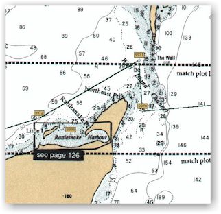
On a west course through the Owen Channel, there is another fine natural harbor for small craft. Rattlesnake Harbor is a great compliment to Club Island Harbor. They are only 6-˝ miles apart and with opposing vulnerable directions. Both are good protection from any direction, but each seems that it might offer a little swell to one point. It happens that these are 180 deg apart.
Owen Channel is a long, wide channel. Half way through the channel is a sudden rise of the bottom in what is noted on the chart as simply The Ridge and shown to be 1 Ľ fathoms. Near the western end of the channel is Stewart Rocks. The surf was breaking on these rocks and as we grew closer, the sound clearly told of the forces at play. Having been in the lee all morning, we knew we were about to break into both the full NW wind and swell. The pounding surf on the rocks telegraphed a warning to reduce sail before leaving the channel.
Out of the channel and open to the full fetch across more than 100 miles of Lake Huron, the wind was blowing a steady 25+ with four-foot seas on our nose. The day was young and it was the short distance day of the cruise so we elected to beat our way towards South Bay. In light and moderate winds the Catalina 250 does well in making good time even when beating, but the high freeboard when in a breeze makes going to weather tough. It was thirteen miles from our anchorage at Club Island to Lake Huron, which had been made in three hours. It is only 8 ˝ miles from Owen Channel to South Bay, but the gps indicated an ETA of six hours. That’s a VMG (velocity made good toward a mark) of 1.4 mph. After a couple of hours it was decided not to be fun and we dropped sails to motor the remaining distance to South Bay.
A ferry from Tobermory on the Bruce Peninsula serving Manitoulin Island stood a couple of miles further out but overtook us rapidly and when well ahead, made a turn and disappeared into the bay, unclear yet to us.
Listening for a weather forecast, we hoped to get word of projected winds for the next day. If the winds became favorable, tomorrow we would continue up the Manitoulin western coast to Great Duck Island and cross to Presque Isle, Michigan in a two day passage, leaving one more day for the south leg to our homeport of Harrisville. If they were unfavorable, then a direct crossing would be a better choice.
South Baymouth Marina catered to the sport fishermen. It was too shallow for fixed keel sailboats to either berth or reach the fuel docks. I hadn’t expected that there was much sailboat traffic up this side of the Island but was surprised that there wasn’t any sailboat accommodations. The eastern shore would be the lee shore to storms from the southwest across the full breadth of Lake Huron. Cruising its coast would require more caution than the west side. I concluded that it was rarely sailed. Raising the swing keel, we motored toward the fuel dock and along the way were hailed by a fisherman who questioned our draft. The harbormaster was an older capable gentleman with a good sense of humor.
The facility was quite new and the pump out equipment was housed in a shed near the water that was built with a low profile. This required the gentleman to squat while reaching in the shed to pull out the hose and pump out nozzle. We commented that it seemed to be a design problem and he assured us that it was not to his liking. The pump out rigging was a bit different than the screw in adapters that are typical. This one simply had a compression head that fit against the deck plate. Informing him that it would be necessary for me to activate an onboard pump got his attention and as he was a rather large man, he held the compression nozzle tight enough to the boat that we could have played a tune on the dock lines. I didn’t blame him for this however. He was able to supply needed ice and told us the next wind forecast would be posted after 4:00 PM.
Motoring into South Bay, we passed the ferry docks and found nice anchorage near the northwest shore. It was Sunday afternoon and there was a large gathering of swimmers at the campgrounds a little further into the cove. Most were probably families of sport fishermen who were enjoying their vacation. South Bay is a deep bay fourteen miles long and two and one half miles across. I was surprised to see such a large beautiful bay with only a few homes on its banks. Then I recalled, that during the winter, the only access to the Island would be from much farther North at Little Current and then over roads that suffered the winter season’s offerings.
 Following
a nap, the weather forecast was posted indicating no change for Monday, NW
between 15-25. Wednesday called for strong chances of widespread
thunderstorms. This meant that to continue up the coast would be directly
into the wind and require the whole day under motor, with perhaps half of
the second day as well, then a strong possibility of being at anchor for a
day in Presque Isle do to thunderstorms.
Following
a nap, the weather forecast was posted indicating no change for Monday, NW
between 15-25. Wednesday called for strong chances of widespread
thunderstorms. This meant that to continue up the coast would be directly
into the wind and require the whole day under motor, with perhaps half of
the second day as well, then a strong possibility of being at anchor for a
day in Presque Isle do to thunderstorms.
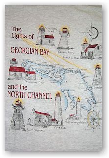
The afternoon was beautiful and would have provided a nice swim had I not punctured the foot. We opted for an early meal around 5:30 and then set off in search of ice cream and possibly T-shirts. The ferry dock was busy and had just finished loading. It appeared that about a half dozen cars would have to wait until the next run. The ice cream was good and we found T shirts that conveyed much of the theme of our cruise with a display of the lighthouses of the North Channel and Georgian Bay [photo to left].
After returning to the boat, the inflatable was stored back within the V berth locker, as we had made the decision in favor of the direct crossing.
 DAY
EIGHT [day8.jpg]
DAY
EIGHT [day8.jpg]
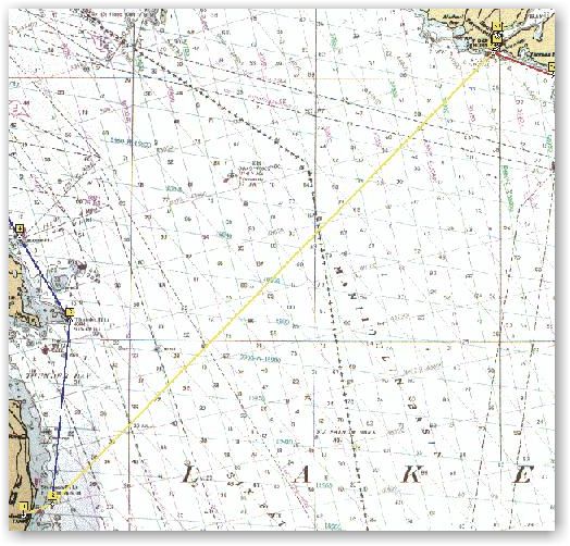
South Bay, Manitoulin Island to Harrisville, Michigan
21 ˝ hours
90 miles
Winds – 10-20 NW
Many things were now in favor of the option to make the direct crossing. Winds were unfavorable to proceed up the west side of Manitoulin but were favorable for sailing for Harrisville in a direct crossing. A clear weather window existed for the ninety-mile crossing that would take somewhere between 18 and 36 hours. A crossing would also allow some night sailing I had wanted in open water. Art had never sailed at night and welcomed the opportunity. Though it wasn’t a major concern, the widespread thunderstorms forecasted on the third day that threatened to harbor lock us at Presque Isle could be avoided. A final concern was that I was mildly tired. The chest infection had me coughing continuously and the gastritis had inflamed my stomach resulting in a nagging pain in my abdomen. These and the slapping halyard had diminished rest. An early return would provide two days of rest before the return trip to Texas. I hate starting a long drive tired and regretted having done so on the up bound trip.
We had enjoyed a nice afternoon nap the day
before, turned in early and rested well. Though waiting a few hours after
daybreak would insure a daylight arrival, neither of us felt that a night
entry to a familiar harbor was a problem. If we encountered poor
conditions we would stand out till daybreak. This would be the longest
open water sailing passage for either of us. 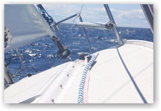 After
agreement to some practical matters such as full time use of life jackets,
harness and tether for all deck work and two-hour watches, we departed
South Bay at 6:30 am. Working under full sail on a starboard beat, we
wound our way through a maze of fishing boats, working waters between
25-60 ft. for Salmon and Lake Trout. Outside of these was a trawler,
working deeper water with nets probably in 80-90 ft water.
After
agreement to some practical matters such as full time use of life jackets,
harness and tether for all deck work and two-hour watches, we departed
South Bay at 6:30 am. Working under full sail on a starboard beat, we
wound our way through a maze of fishing boats, working waters between
25-60 ft. for Salmon and Lake Trout. Outside of these was a trawler,
working deeper water with nets probably in 80-90 ft water.
R&R found her rhythm, and the wheel was
locked and required very little attention for half of the crossing. By
late morning the higher hills of Manitoulin dropped from view and we were
alone in open water. Late afternoon brought some of the best sailing
conditions that I have experienced. The wind had clocked a little, placing
it a little more to beam but still close enough for the boat to
self-steer. Wind speed was about 18, with two-ft seas. R&R was busting
along between 6.5 and 7.4 knots. 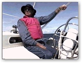 A
constant whoosh and spray each time we met wave, but the entry was not so
that it slowed the boat or sent spray over the deck. Under full main and
about 90% headsail we flew along for the next two hours with no attention
to the helm. I was glad that I had brought the camcorder and couldn’t
resist standing in the companionway and documenting such a glorious
sailing condition.
A
constant whoosh and spray each time we met wave, but the entry was not so
that it slowed the boat or sent spray over the deck. Under full main and
about 90% headsail we flew along for the next two hours with no attention
to the helm. I was glad that I had brought the camcorder and couldn’t
resist standing in the companionway and documenting such a glorious
sailing condition.
Our first boat spotting was of a southbound
ore ship
It’s rear pilothouse and forward mast, all that we could see, seemed too
far apart to be one boat. The second was spotted to the north bearing
south with only a slight profile of her port side. Hmmm! Firing up the
laptop, the proper chart and our position soon appeared. A southbound
shipping lane was only four miles ahead. The approaching ship was on that
lane, and the timing to crossing would be close. Sticking my head out of
the companionway to call for sheeting out and slowing the boat, I was
preempted with, "we are going to cross behind it!" I concurred!
Slacking our speed considerably, we watched 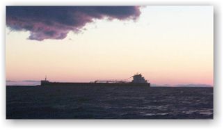 it
pass. Back to the computer, clicking on the south bound track, showed we
were 1 Ľ mile from it, and judging the distance, it appeared that the
ship was right on the track. Our estimate was that in open water with no
land in sight, had we not slowed, our courses would have brought us within
hailing distance…that’s too close for a difference of 975 ft in
length.
it
pass. Back to the computer, clicking on the south bound track, showed we
were 1 Ľ mile from it, and judging the distance, it appeared that the
ship was right on the track. Our estimate was that in open water with no
land in sight, had we not slowed, our courses would have brought us within
hailing distance…that’s too close for a difference of 975 ft in
length.
Late in the evening we started getting some
buildup of clouds marking a weak front. At the first hint of wind change,
we double reefed the main, and prepared the furling line to a cabin top
winch. Any hint of cool air, we would drop the main and furl to about 30 %
headsail. We both wanted to make the entire crossing under sail and hoped
the weather would cooperate. Though the clouds didn’t seem to rise too
high, there was one that was as unusual as I’ve seen. From a lower bank
within the middle of the cell, a long funnel cloud drifted behind
horizontally several hundred yards and rotated to provide its form. I
quickly snapped two pictures, 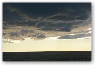 both
of which were in stages of it dissipating. From full form of the funnel to
total disappearance was only about ten seconds. Though they were dark an
ominous looking, none of the clouds were more than five thousand feet and
offered no high winds, rain or storm activity. The front however, brought
an increase of winds to about 25 mph and a northerly shift; we single
reefed the main with partial headsail. The wind changes ended the
self-steering ability of the boat as well as use of the autohelm as
conditions were now beyond its capabilities.
both
of which were in stages of it dissipating. From full form of the funnel to
total disappearance was only about ten seconds. Though they were dark an
ominous looking, none of the clouds were more than five thousand feet and
offered no high winds, rain or storm activity. The front however, brought
an increase of winds to about 25 mph and a northerly shift; we single
reefed the main with partial headsail. The wind changes ended the
self-steering ability of the boat as well as use of the autohelm as
conditions were now beyond its capabilities.
Dusk brought the first glimpse of land on the Michigan side. It would be Thunder Bay Island and a quick check with the binocular compass and the chart verified this. Soon it darkened enough for the beacon of the lighthouse to be seen. As it grew darker, the glow of Alpena’s lights was clear. Our destination was thirty five miles south of this first land observation. Because this was Art’s first night sailing, I reminded him that to go over board at night in cold water might mean disaster, and that most over boards occur when getting relief. Standing in the dark and keeping balance requires caution.
I relieved Art at the helm at 10:00 PM and he went below for a nap. Shortly thereafter, a large blazing meteor streaked downward and exploded like 4th of July fireworks. I once saw a meteor with a large fireball, burn all the way to impact at close range, it was dramatic. This exploding meteor was the first I’ve seen like it.
A waypoint standing out about two miles
from Harrisville harbor had been selected prior to leaving South Bay and
we had sailed the 90-mile distance with no more than 1.4 miles cross track
error. 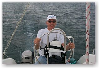 This seemed amazing
considering that half was sailed with the wheel locked and the boat
self-steering. A near full moon rose about midnight and it was about 3:00
am when we reached the offshore waypoint. With Art at the helm making for
the breakwater, I found it necessary to jog him to starboard to clear the
rocks at the entrance. It would have been disastrous to founder on the
breakwater of the homeport after not even a hint of an incident in eight
days of cruising. Art had looked at some lights in the vicinity of the
harbor and lost a little night vision, but had seen the rocks about the
time that I had called for the starboard turn. We entered and anchored as
quietly as possible to be courteous to those within.
This seemed amazing
considering that half was sailed with the wheel locked and the boat
self-steering. A near full moon rose about midnight and it was about 3:00
am when we reached the offshore waypoint. With Art at the helm making for
the breakwater, I found it necessary to jog him to starboard to clear the
rocks at the entrance. It would have been disastrous to founder on the
breakwater of the homeport after not even a hint of an incident in eight
days of cruising. Art had looked at some lights in the vicinity of the
harbor and lost a little night vision, but had seen the rocks about the
time that I had called for the starboard turn. We entered and anchored as
quietly as possible to be courteous to those within.
 The
crossing was a grand finale to a great cruise of over 380 miles. Art was
good company and a good sailing companion. We found the waters of the
North Channel and Georgian Bay to be beautiful and Canadian hospitality
great. The view from the outlook north of Killarney and the many other
sites seen will never be forgotten. Favorable weather conditions with good
winds provided great sailing.
The
crossing was a grand finale to a great cruise of over 380 miles. Art was
good company and a good sailing companion. We found the waters of the
North Channel and Georgian Bay to be beautiful and Canadian hospitality
great. The view from the outlook north of Killarney and the many other
sites seen will never be forgotten. Favorable weather conditions with good
winds provided great sailing.
Arlyn Stewart
C250 w/b "R&R"
Submitted: October 22, 1999