|
|
|
|
|
|
|
|
|
|
|
|
|
|
|
|
|
|
|
|
|
|
|
|
|
|
|
|
|
|
|
|
|
|
|
|
|
|
|
|
|
|
|
|
|
|
|
|
|

Halo Around the Sacred Isle
Part 2: Days Three and Four
By Arlyn Stewart
 DAY
THREE
DAY
THREE
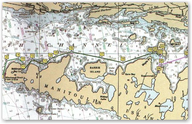
Meldrum Bay to Clapperton Bay
44 miles
9.45 hrs
Winds – S 12-18 turning WNW
On the way back from visiting the showers, a moderate rain started. We dug out the pop-top enclosure and snapped it in place for its first use and decided that it was suitable for motor use. There did not seem to be any high winds or thunderstorms associated with the rain so we slipped the dock lines and departed for Mudge Bay. Under motor and foul weather gear we motored east towards Vidal Island where we planned rounding it to the south between it and Manitoulin. This would require careful chart work as several shoals existed but according to the charts there were navigational aids that would guide us through. This proved to be true and was made much easier by the use of gps and the previously marked waypoints of each navigation aid. Without the gps, a first time through would have been tedious.
Continuing east to Cape Roberts, past Barrie Island, across Julia Bay and down into Gore Bay for a look. We had not planned to stop here but did want to see the bay and the town. Compared to Meldrum Bay, we had come to the city. Gore Bay had a large, modern marina with lots of activity. The town led out from the waterfront into the surrounding hills . Many sail and power craft were nestled in slips as well as several on moorings in a fairly expansive naturally protected harbor. Needing no fuel or provisions we did a slow tour of the waterfront area and continued on towards our destination of Mudge Bay.
Following the rain—ending shortly after we had gotten underway—the winds had provided WNW 12-18 pushing us on our first run. At Cape Roberts we swapped the pole to wing on wing for the dead downwind run to Gore Bay and when leaving we continued the run towards Mudge Bay. Approaching Maple Point, we decided an anchorage at Clapperton Bay looked doable. There was a small island in the bay that would provide a lee from the westerly. There are several shoals between Maple point and Clapperton Island but they are clearly marked. The change of plans to anchor north of Mudge Bay and Kagawong turned out well. As we rounded the little island we found two sailboats and two powerboats that had chosen to anchor in the lee as well. We had covered 50 miles in nine hours and forty-five minutes, including the excursion into Gore Bay. All but the first 5 miles in the rain had been under sail. This was the warmest day so far, probably because it was down wind so we decided an afternoon swim was in order. The water in the bay was a little warmer than that of Presque Isle harbor, but still was cold when first getting in.
After the evening meal we pulled the inflatable from the V berth locker and set it up with little difficulty by unhooking the lifelines and placing the dinghy across the coamings. Swapping the 8 hp Honda over to the inflatable is not a problem for two men but I thought to myself that to do it single-handed would require significant effort and planning. A safety precaution we observed was to keep the motor tethered on a short rope to the stern pulpit while making the swap each time. We neither wanted to lose the motor to the bottom or have it immersed. The Honda 8 will get the sport boat up on plane with two men weighing 410 lbs. We enjoyed motoring about the bay but darkness soon approached.
DAY FOUR
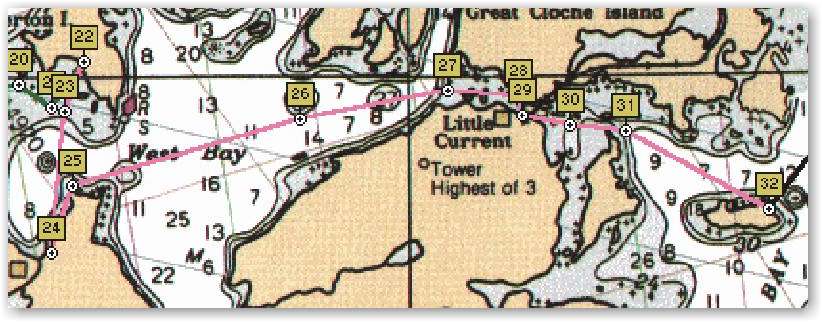
Clapperton Bay to Browning Cove
32 miles
8.75 hrs
Winds - S 8-12
Needing ice, we motored south into a moderate southerly wind the 6.5 miles to Kagawong. We topped the fuel tank which didn’t require much and bought ice and enjoyed stretching our legs for a walk through the large marina. This place must do a big business in inflatables as there were more than 8 models on display. Their chandlery of sailboat rigging and fittings was thin however. At the 1.7 Canadian exchange rates I wondered if there were some good buys. I had promised myself that this cruise was to be a financially disciplined one so didn’t allow myself to get interested in any of the candy store goodies. I did spend the Toonie that I had received as change at Meldrum Bay on the ice. A Canadian Toonie is a large coin with an insert. The outside ring a silver color and the inside coin copper I would guess. Its value is two dollars, or slightly more than a dollar US. Kagawong had the appearances of being an older town than Gore Bay, but I couldn’t say if this is true. I was tempted to buy a T-shirt, but the selection here wasn’t large.
Leaving Kagawong, we made for Trudeau Point and the channel between Goosberry Island and Tache Island. There are several very low islands in the vicinity of this channel. The water level being near datum has some advantages in that during high water, some charted islands are not visible and can cause a mariner to think he should be seeing land when there is none visible. This can be confusing and without local knowledge or a sharp appreciation for the chart, can tempt him into mis-identifying a piece of land as the island on the chart, when in fact that island may be lurking very close to the hull. R&R has not touched bottom yet. Hope the rest of the cruise can keep that record.
Crossing West Bay we entered the west end
of the channel that leads to the community of Little Current, situated on
the banks of the narrow channel between Manitoulin Island and the Canadian
mainland. This is the only location on Manitoulin Island close enough for
a bridge to the
mainland. The only other vehicle traffic to the Island occurs at South Bay
via ferry from the Bruce Peninsula. In winter, the rotating bridge across
this channel is the only access to this large Island, other than snow
mobile across the ice. The bridge opens each hour on the hour to allow
boat traffic to pass. Little Current is a name given I expect with tongue
in cheek as the current in this channel can become strong if winds drive
water from the large expanses of water on either side of the channel. 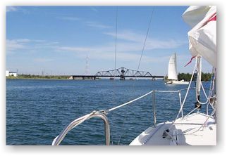 The
charts warn of currents to seven knots. We have a twenty-minute wait for
the bridge to open and approach the southern side of the channel and park
in the lee.
The
charts warn of currents to seven knots. We have a twenty-minute wait for
the bridge to open and approach the southern side of the channel and park
in the lee.
A 31’ corsair enters the vacant area
close to the bridge. The first mate drops the headsail but they keep the
main up and sail circles for a fifteen-minute wait. He makes the passage
through under sail but is the only one to do so, I conclude that even
though he seems to be a capable sailor that it is a little fool hearty to
risk collision in the tight area congested with boats waiting for the
bridge to open. It doesn’t take long, of course for several boats to
retreat and give him more room. The boat has New Mexico registration. Even
before the bridge starts to open, we notice two power craft make a run
toward the bridge, they evidently have a grasp of local affairs and know
the exact timing of the bridge. 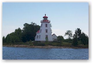 Sure
enough, as they approach, the bridge swings open though I am surprised
that it swings toward the oncoming traffic instead of away. It seems
backward but I expect there is a good reason for it. Boats fall into
single file and we motor through the channel at about six knots.
Sure
enough, as they approach, the bridge swings open though I am surprised
that it swings toward the oncoming traffic instead of away. It seems
backward but I expect there is a good reason for it. Boats fall into
single file and we motor through the channel at about six knots.
Out of the lee of the channel we bend all
sail up on a beam reach toward Browning Cove on Heywood Island. The
Corsair is fast and dusts us easily. We round close to the north point of
Strawberry Island and snap a picture of the light house and alter course a
few degrees toward our evening anchorage at Browning Cove. It will be an
ideal anchorage in the lee of Heywood Island. There are many boats within
the main anchorage and we move off through a channel to find space in
another inlet. Shortly after anchoring, an elderly couple approach in
their dinghy and strike up a conversation resulting from the Texas
registration. 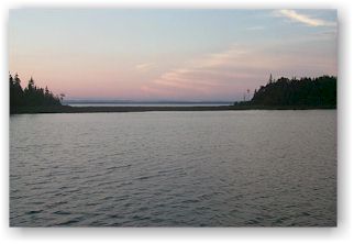 Their home is
on George Island to the south of the channel at Killarney. The man relates
that they have lived at Killarney since the early fifties, which was
before the highway was brought to the community. He describes life in
those days, with all support for the community coming from Little Current,
twenty-five miles to the west by boat in the summer and by team and sled
over the ice in the winter. They are a handsome cheerful couple somewhere
in the middle of their golden years. Both their faces wear what seems to
be a natural well used smile and their voices indicate relaxed and patient
mannerisms. I quickly observed that neither interrupted the other and they
looked at each other for some signal as to who was going to respond to a
question. It was a joy to have met them. We asked for local information
about the hiking trails at Baie Fine and received very well delivered
directions that were easy to follow and understand.
Their home is
on George Island to the south of the channel at Killarney. The man relates
that they have lived at Killarney since the early fifties, which was
before the highway was brought to the community. He describes life in
those days, with all support for the community coming from Little Current,
twenty-five miles to the west by boat in the summer and by team and sled
over the ice in the winter. They are a handsome cheerful couple somewhere
in the middle of their golden years. Both their faces wear what seems to
be a natural well used smile and their voices indicate relaxed and patient
mannerisms. I quickly observed that neither interrupted the other and they
looked at each other for some signal as to who was going to respond to a
question. It was a joy to have met them. We asked for local information
about the hiking trails at Baie Fine and received very well delivered
directions that were easy to follow and understand.
An afternoon swim provided refreshment and
cleanup prior to the evening meal in the cockpit. For the only time on the
cruise we had a visitor aboard for the meal. 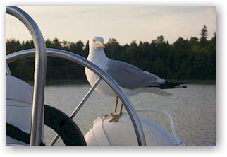 Cookie
Monster was immaculate looking for a beggar. He was perfectly white and
rich gray, handsome without a flaw or the least mottling. Must have been
quite a ladies bird with being both handsome and not a bit shy. The missus
didn’t like the proceedings. The game plan was for the two of them to
beg from a reasonable distance and share the booty. His waltzing around
the cockpit was a serious departure from her instructions and she flew
around nagging him about it. But he paid her little mind and continued to
enjoy the dry cookie that needed an adequate milk supply for dipping.
Cookie
Monster was immaculate looking for a beggar. He was perfectly white and
rich gray, handsome without a flaw or the least mottling. Must have been
quite a ladies bird with being both handsome and not a bit shy. The missus
didn’t like the proceedings. The game plan was for the two of them to
beg from a reasonable distance and share the booty. His waltzing around
the cockpit was a serious departure from her instructions and she flew
around nagging him about it. But he paid her little mind and continued to
enjoy the dry cookie that needed an adequate milk supply for dipping.
After supper we went visiting. First stop
was the Corsair where we inquired about the tow from New Mexico, done with
a Chevy Suburban with 454. In the process of preparing their evening meal,
we moved on and inspected probably more than two-dozen boats. A very
interesting old workboat had been converted into a family boat and
seemingly had a score or two of kids aboard. In the larger bay area were
many large sailing and power craft and we slowly examined each and shared
comments. 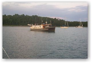 On the perimeter
of these boats we found the couple that had visited us, aboard a
beautifully maintained old power sailor. I commented that the hull looked
in great shape for a wooden boat. The gentlemen’s reply was that she
wasn’t wood, but had a fiberglass hull and a wood deck. The hull was
molded in a planked veneer appearance and from twenty feet off with the
wood deck, and wood top structure, looked like an all-wood boat. They had
a charcoal pit going with a cut of mutton on it that had been found at a
bargain price. I glanced at their rubber dingy and noted the very old
outboard and realized that these were folk shaped from much of the same
stuff that my father was. When he was finished with a dollar, the green
was pretty well squeezed out. I was a senior in high school before I wore
any thing on my feet but brown brogans, and bought them myself. When I
suggested that I had the money to make up the difference between the
brogans and the low cuts, his reply was that he still wasn’t getting his
moneys worth. I paid the whole.
On the perimeter
of these boats we found the couple that had visited us, aboard a
beautifully maintained old power sailor. I commented that the hull looked
in great shape for a wooden boat. The gentlemen’s reply was that she
wasn’t wood, but had a fiberglass hull and a wood deck. The hull was
molded in a planked veneer appearance and from twenty feet off with the
wood deck, and wood top structure, looked like an all-wood boat. They had
a charcoal pit going with a cut of mutton on it that had been found at a
bargain price. I glanced at their rubber dingy and noted the very old
outboard and realized that these were folk shaped from much of the same
stuff that my father was. When he was finished with a dollar, the green
was pretty well squeezed out. I was a senior in high school before I wore
any thing on my feet but brown brogans, and bought them myself. When I
suggested that I had the money to make up the difference between the
brogans and the low cuts, his reply was that he still wasn’t getting his
moneys worth. I paid the whole.
Arlyn Stewart
C250 w/b "R&R"
Submitted: October 22, 1999