Notice:
The advice given on this site is based upon individual or quoted experience, yours may differ.
The Officers, Staff and members of this site only provide information based upon the concept that anyone utilizing this information does so at their own risk and holds harmless all contributors to this site.
We just added a weather station to our club, http://www.ninnescah.org/weather/wx.htm I think the sampling rate is too high but t6hey are still playing with the settings. I know some clubs and marinas have dock cameras too. What do you have?
Interesting thing is that when I entered my zip code at the top of your link screen, I then get one of the main weather stations I use which is Weather Underground...www.wunderground.com. But it does not have the fancy wind indicator or the graphs that your local weather station has utilized. Weather Underground does provide weather forecasting in 3 hr time segments when the zip code detail screen is clicked for a specific day.
Does your club have a Davis weather station? Ambient's Virtual Weather Station software is great. I've been using it for my weather station at home for 4 or 5 years.
For lake webcams check out these two links here in Texas.
Austin Yacht Club on Lake Travis --->>> http://ayc.dns2go.com/ They have a nice website too!
The webcams at http://www.sectlive.com/webcam.htm show the Mystic River and, next spring, me going by (or waiting for the drawbridge). You can control the cameras.
Southern Oregon. SUN NIGHT...S STORM FORCE WINDS 55 KT WITH OCCASIONAL GUSTS TO 70 KT... RISING TO HURRICANE FORCE WINDS 65 KT WITH OCCASIONAL GUSTS TO 85 KT. WIND WAVES 30 TO 40 FT. RAIN.
MON... S HURRICANE FORCE WINDS 65 KT. WIND WAVES 36 TO 39 FT... BUILDING TO 39 TO 42 FT IN THE AFTERNOON. RAIN.
NW California...S WIND 45 TO 50 KT WITH GUSTS TO 60 KT. COMBINED SEAS 26 TO 31 FT WITH A DOMINANT PERIOD OF 9 SECONDS.
30-40' waves... at 9 seconds. Oh my.
I think I'll check the mooring lines on the boat tommorrow.
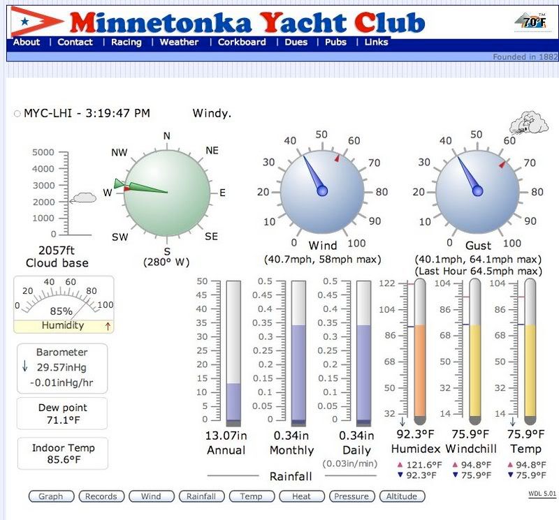
This is an actual screen shot from a storm earlier this summer. This was the last recorded image before the wind sensor was destroyed as the storm came through! Quite a lively afternoon as I recall.
Things are a little rough this morning in the PNW. The Columbia river bar is closed with seas at 44ft and wave heights reaching 70ft.
From the NOAA site for the Oregon coast:
.MARINE...FORECAST APPEARS TO BE ON TRACK. WINDS INSIDE 20 TO 25 NM FROM SHORE APPEAR TO BE RIPPING PRETTY GOOD. BUOYS 29 AND 50 HAVE BEEN NEAR HURRICANE FORCE GUSTS THIS EVENING AND WINDS AT THE COAST HAVE HIT 129 MPH AT BAY CITY. SO HURRICANE FORCE WIND WARNING FOR ALL WATERS LOOKS TO BE IN GOOD SHAPE...ESPECIALLY SINCE MODELS STILL SHOW STRONGEST WINDS TO COME OVER THE NEXT FEW HOURS. SEAS ARE UP ABOVE 40 FT IN THE NORTH...AND ABOVE 30 FT SOUTH. WENT WITH BLANKET +40 FT SEAS ACROSS ALL WATERS THROUGH THIS AFTERNOON...AND MID 30S THROUGH TONIGHT. WINDS FALL TO STORM FORCE THIS AFTERNOON AND EVENING...BUT DO NOT LIKELY FALL TO GALES UNTIL TUE MORNING.
Update tonight: AFTER REGISTERING 70 FT SEAS BUOYS 29 AND 50 ARE ADRIFT AND MAY RUN AGROUND TONIGHT.
ok< something wierd is going on w? my posting< getting these wierd characters and i don"t know why>>> it"s like caps lock is on< but it"s not>
anyway< we don"t have seventy foot waves< but it"s pretty nasty> with all the rain in the last twenty four hours and a pretty high tide< the bay here was the highest it"s been in three or four years> roads flooded< cars underwater< it"s a mess!
Ok, fixed the keyboard. Any of you weather buffs want to know what's happening in the south end of Puget Sound, here's our Olympia weather station:
Notice: The advice given on this site is based upon individual or quoted experience, yours may differ. The Officers, Staff and members of this site only provide information based upon the concept that anyone utilizing this information does so at their own risk and holds harmless all contributors to this site.