|
|
|
|
|
|
|
|
|
|
|
|
|
|
|
|
|
|
|
|
|
|
|
|
|
|
|
|
|
|
|
|
|
|
|
|
|
|
|
|
|
|
|
|
|
|
|
|
|

North Channel 2000
by Arlyn Stewart
Part 1 - Too Much Energy
My annual great escape from the Texas heat of August pushes me north to cooler temperatures and good sailing waters. My boat in tow is a 25-foot sailboat setup to handle a week or two cruising but is light enough to haul the long distance.
Raised in northern
Michigan with most of my brothers and sisters there, the area is a natural
place for me to vacation as it provides some of the finest cruising waters
available. Last years cruise
was around Manitoulin Island, the largest fresh water island in the world.
This year plans are to cruise around the western section of the
North Channel from west near St. Mary’s River to near Little Current to
the east. Michigan’s
Drummond Island, and Canada’s Cockburn and Manitoulin Islands border the
North Channel to the south with the Ontario Province on the north.
Within these boundaries are hundreds of islands and enough small
boat anchorages 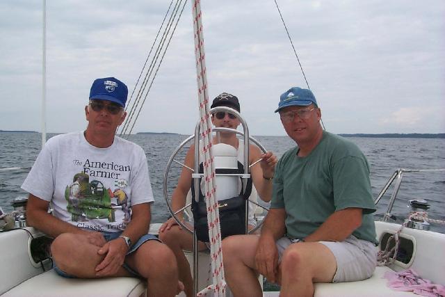 to provide easy day sails from one location to the next.
Great Lakes waters provide some of the finest fresh water cruising
the world offers. Many,
including myself are drawn back often.
to provide easy day sails from one location to the next.
Great Lakes waters provide some of the finest fresh water cruising
the world offers. Many,
including myself are drawn back often.
Crew this year is my brother-n-law Art, who sailed last year and my nephew Matt. Last year Matt took us to the harbor for our send off and in last years story, I narrated his wishing that he could join us. An invitation this year found him with vacation time and a quick effort to get his ducks in a row to join us.
The road trip from Texas to Michigan took two days with a stop at a campground just west of Indianapolis where the manager remembers me from a previous year. The water ballast boat sets low on the trailer and the swim ladder and walk thru transom provide almost as easy boarding as stepping into a travel trailer. Needing no hookups the fee is $5 which is a good bargain for the safety and quiet provided by a campground compared to a rest stop.
Arriving at my sisters on Saturday afternoon, she makes several calls to setup a Sunday afternoon family get together. Sunday morning, Art and I retrieve his pop up camper from the fair grounds and help his son tear down and clean up stock pens for the goats, rabbits, ducks and chickens his boy has competed in 4H. At the cook out, all have a good time and I discover that I’m rusty at horseshoes. Another sister, who has worked during the day, visits through the evening. It’s good to see everyone.
Early Monday, the boat setup goes well except a recently replaced cable is not routed properly causing the swing center board to hang on the trailers aft cross member. A rope sling around the boat and back to a winch works well to lift the centerboard and get us on our way. There will be opportunity to reroute the cable later. Art's brother offers to store the truck and trailer and soon after setup, we are sailing north along Michigan’s Northeast coast.
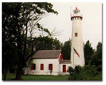 The
first point of interest is the traditional looking lighthouse at Sturgeon
Point. It remains active
and offers tours and a museum. During
part of the 1800s and early 1900's there was a manned rescue station
barracks at this location.... but those stations have been closed for many
years.
The
first point of interest is the traditional looking lighthouse at Sturgeon
Point. It remains active
and offers tours and a museum. During
part of the 1800s and early 1900's there was a manned rescue station
barracks at this location.... but those stations have been closed for many
years.
The moderate west wind is ideal for the northerly course. This is a treat as the three previous years, this long 55 mile leg has been into a north wind requiring power the whole distance. With all sail up, we seldom fall below 5 knots. At Thunder Bay Island, our course bears west a few degrees and combined with a slight northerly wind shift.... we find ourselves on a close beat at reduced speed. In fact, the course finds us standing out a bit from the rhumb line to Presque Isle Harbor. During the late afternoon as the effects of onshore wind pressures lesson because of less land heating, the west wind freshens to a breeze and we find ourselves crashing hard into four-foot swell and greatly diminished speed.
With our course now standing out too far, sail is dropped and under motor a course is set for the outer buoy at Presque Isle Harbor. The chop has a short period and steep sides and often washes over the deck. Matt gets his first lesson with the need to dog down the forward hatch, rather than just close it. Some of our sleeping gear gets wet and speed is reduced to about 3 knots to avoid the need to get into foul weather gear, as the water is cold.
Sailing this leg has taken us about 10 ˝ hours compared to 8 ˝ in previous years under motor. Generally it is difficult under sail to maintain the average speeds that are provided under auxiliary power. There are exceptions of course, and they provide great sailing enjoyment. Another factor is that after rounding Thunder Bay Island, we have been on a beat into significant swell and on a course that stood out from Presque Isle Harbor.
The very nice marina at Presque Isle offers temporary dockage of up to 2 hrs for five dollars. The Harbor Master suggests we take all the time needed, as there are plenty of slips. This is a bargain and time enough for a shower or visiting the very nice restaurant for an evening meal. Their chicken fettuccini is great, with a large portion good to the last bite. At the store across the street, we get milk and a few other necessities, including ice cream. But I just asked for one scoop...its a race to keep up.... should have gotten the waffle cone or maybe even elected the Styrofoam cup. Now after 10 pm, dusk approaches as we leave the breakwater and take up anchorage in the very nice natural harbor protected from swell from all but the east.
The morning brings continued WNW wind but greatly diminished from yesterday and we sail off the hook but shortly add power and turn NNW for Detour Passage. This is the primary passage from the St. Mary’s River system south from Lake Superior. To the west of this passage is Michigan’s Upper Peninsula, home of UPers, compared to the Trolls that live under the Mackinaw Bridge. To the east is Drummond Island, Michigan.
A motor sail course is set for this close beat with winds just enough to fill the sails while maintaining 5 knots as this is a long passage of more than 60 miles. The weather forecast is for spotted thunderstorms south of a line 1/3 of the way down Michigan’s lower peninsula, but by 11 am.... thunder can be heard far to the west and the skies grow darker and it begins to rain. Fearing some squalls and knowing the sails aren't providing significant power.... they are doused, after which we go below for lunch of turkey and cheese sandwiches. The helm is given to the autopilot for the remaining 26 miles across Northern Lake Huron.
As Matt naps, suddenly a bright light flashes in the cabin windows and the ka...boom of a simultaneous explosion accompanies. It either hit us or was very close. Sound travels at a little more than 300 yards per second. A second is actually a very long time relative to our reflexes and both Art and I confirm that the explosion and flash were simultaneous. Whether the lightening hit the water or was cloud to cloud I don’t know but I believe it was within 200 feet of the boat. I doubt that it was closer however than 50 or we probably would have sensed some feeling of the charge. The sound shock wave shook the boat.
Looking up to the masthead, the windex is still moving on top of the mast, causing me to doubt that we took the strike. There is also no telltale sign of static charge felt. All electronics continue to work and a visual check of the boat turns up no signs of a hit. The bilge is checked after a minute and is dry. It occurs to me that if we had been hit, the gps and radio may have been knocked out. I have handheld versions of both, but the gps would take a minute or more to get a fix as it is an older Garmin 45. For this reason, I log our position every 15 minutes until we reach Detour Passage and decide this should be done any time weather threatens. All previous thunder was far off, and no more was heard after this strike.
Lightening on the water is often discussed among sailors. Each captain faces a decision between two schools of thought, to ground or not. This is often made with little confidence that the right choice is clear. The facts in this incident are that the strike was the only one within probably 10 miles and that it was within a couple hundred feet of the boat but didn’t hit the boat. Why hadn’t the 30 foot mast attracted the strike? I think its because lightning is not seeking the tallest object but rather the closest ground path and with the boat ungrounded, the boat is no closer a path than the water surface. I believe that had R&R been grounded….it would have taken this strike and if so, it would then have been a question of whether the grounding system was adequate to handle the hit without damage. Does this experience cause me to feel safer ungrounded? Only slightly, as I agree that the best choice would not to be out there when the potential exist. Our weather window seemed ok from the forecast but nature gave us another lesson in her unpredictability.
When Matt awoke, his dad signed the question, “ Had he felt the lightning strike?” He hadn’t. Confined to the cabin in the rain, we play crazy 8’s which continued to be our on boat recreation for the duration of the trip. Close to Detour Passage we dress in foul weather gear and move to the cockpit as there are often large freighters in this channel. The freighters are usually good about providing security calls and one calls and announces that in 30 minutes he will enter the passage bearing south and turn west to the Mackinaw Straits. This puts us in the channel with him but it is wide and not a problem. Another, which has not made a security call, follows him and turns southeast down Lake Huron There is a lot of ferry activity across the channel, perhaps two, maybe three making continual crossings.
Part 2 - A Lee Shore
Our destination is Harbor Island, not far off Drummond Islands north west coast. Harbor Island is a rather unique island living well up to its name. It is shaped like a horseshoe, having a fairly narrow entrance and the bay within fills most of the island with 5-12 foot of depth and good holding. The bay is large enough to accommodate many boats and we take a position 150 yards east of the two sailboats at anchor. The intermittent rain continues and during the night its necessary to open and close the forward hatch several times in an attempt to get good ventilation without additional water on the bedding.. The pop-top companionway cover was installed after we cleared Detour passage. Used previously under outboard power, it helps keep water out of the cabin and offers good headroom below.
After breakfast of instant oatmeal, juice and hot chocolate we make the short run to Drummond Island marina for gas, ice and pump out. Typical to many harbors, a store is a couple of miles off but there are bicycles here to rent or borrow if supplies are needed. Our stay is just long enough to service the boat.
Heading north in heavy overcast skies with a continued light west wind, a course is desired east of Harbor Island but having not anticipated putting in at Drummond Island, no waypoints are loaded for this course and it has a couple of shallows and lots of small islands. I am soon disoriented and in the heavy overcast cannot see a channel buoy to the northeast. Off of one of the islands, there are two milk jug markers. Are they marking a channel or shoal? We probe gently forward and discover the underwater ridge. Using the glasses, the missing buoy is finally spotting giving a position to determin which Island we are near and the proper course to its left.
Rain returns about the time Canadian waters are entered and the stars and stripes are lowered, as we have no Canadian ensign. We do see several yachts during the cruise that are flying the US ensign and no Canadian. This, according to Chapmans is discourteous. As the wind increases and the rain becomes miserable, a course is set for Milford Haven on the Western reaches of the North Channel. Just prior to reaching near lunchtime, the sun starts to shine and the wind freshens, inviting us to press on north. With the bay right in front of us however; time is taken to explore it. Haven seems an appropriate word and I envision that this location has given refuge to many a mariner during foul weather. There are two inhabited cabins ashore and with sun and a nice breeze blowing, we drop the hook on a short rode and pull out some damp bedding to dry while eating lunch. An increasing breeze starts dragging us on our short rode so when finished eating, we exit the inlet and sail north under ideal conditions.
The west wind drives full sails well and many times over the next few hours, we make 6.2 knots on this beam reach. Conditions are fantastic with temperature in mid seventies, 12-15 knots of wind on the beam and only slight chop. Farther north and into the area open to the west towards the Northern access to the St. Mary’s River, the wind and chop increase and a single reef is taken and a course set for Thessalon located in the northwest of the North Channel. Government Docks here will offer a telephone to check in with customs.
A very friendly harbormaster assists with lines and points me toward the phone. My instruction to crew to stay aboard until after customs check in is countered by the harbormaster who says, “Not a problem here.... customs is 400 miles away and their binoculars aren't that good.” Customs was easier than last year when we had to wait onboard for an hour and half. The lady asked for boat registration and evidently had it in the computer because she then verified my name and homeport. She asked if crew were same or different and I offered one additional...that was it, we had our pass number with out a hitch.
A 20-minute walk to town grocery stretches legs. Back at the docks, the harbormaster is chatting with the OPP (Ontario Provincial Police) officer who perhaps staffed the government docks and kidded us about whether we had visited the grocery or liquor store. I am not sure of the liquor laws in Canada, other than one must declare to customs any alcohol or tobacco on board. None of R&R ‘s crew drinks much, so there is none aboard.
The harbormaster asked if we planned on the East Grant Island anchorage and affirming, he offered that it was a good one. I raised the concern about how it was with a strong west wind as we had today and he remained silent. Either he didn’t know….or didn’t want to ruin our fun of discovering that answer ourselves. Leaving the harbor, a dogleg to the west immediately confirmed the wind was building. Out of the harbor, R&R was put on a run east to the expected evening anchorage at East Grant Island. Under a single reefed main and partial headsail speed was generally near 6 knots. On the Great Lakes, 5 knots of wind is usually equal to about a foot of wave height. The swell was now at or nearing four feet and had built about a foot in the last hour. Prior to reaching East Grant Island, it would build another foot with winds at 25 knots and boat speed of 6 knots under double-reefed main and a spanking of jib, just enough to settle the helm. The good news was that in previous conditions like this, rudder torque had eaten my lunch and now after the modifications to the rudder, the helm was almost effortless. The bad news, the chop period was so short, that the usual fun of surfing down waves was almost non-existent.
Prior to reaching the island, I inspected the chart carefully. The bay on East Grant Island was open to the west and would not be suitable...but there was a northern inlet in the northeast corner of the bay provided by a small island. Unfortunately, my chart didn't show the depth of this inlet and my chart book didn’t provide the smaller chart indicated to exist. There was temptation to assume given the existence of a smaller chart that the inlet was navigatable.... but I didn't know, and therefore couldn't make the assumption.
Shoaling was indicated off both the southwest and northwest corners of the Island and guarded each corner of the bay. Well off, breaking water could be seen throwing spray airborne around the shoals. Swell was now running five feet into the bay. I was concerned. While the Honda 8 had never died on me in the eight years I've had it, we would be very vulnerable if it quit. I didn't like entering the bay knowing it would be very hard sailing out of it against 25 knots. The shoals on both sides extending too far out to get a good look at the inlet that would provide the only acceptable anchorage, without making some serious commitment. The first thing checked was the ability to motor back out. Turning the boat west into the wind to get the main down, I asked for a gps speed over ground. Between 2.5 and 3 knots against the 25 knot wind and bad swell, better than I thought. It was doable, but left little margin for error. Getting the main back up if we motored in would be a problem. The sail slides just weren't running free enough to be certain that it could be hoisted without the boat close onto the wind. Having sailed under double reefed main in winds like this before, R&R tacked thru easily.... but that was on an inland lake with a lot less swell. Would she stall into the swell and not come around? It would take a multitude of tacks to get out of the bay and only one blown one to be onto one of those rocky shoals. I didn't like depending on the jib to make tacks. A sheet could foul. If we sailed in under double-reefed main, could I sail directly into the inlet? Or, would I need to get the sail down in the surf?
In moments like this.... a multitude of thoughts enter...get processed...and a push for a decision. If certain that I could go directly into an inlet...it may have been doable.... without that knowledge, this was risky. My last thought bearing on the decision was, this is a bad lee shore…. Why are you even considering it?
Turning the boat back into the wind to hoist the main provided a wild ride. While probably not the most swell that R&R had experienced, the wave period seemed to be the shortest encountered for 5-foot conditions making it almost impossible to time a turn and avoid taking a wave from somewhere abeam. The bow made it around only about 20 degrees into the next wave that rolled R&R 45 degrees to starboard as the motor punched through the turn and forced the bow to point into the sky giving the feeling of going airborne. These turns are best taken with the outboard in mind. With a starboard mounted motor, make the turn to the starboard so that when the wave rolls the boat, the motor will drive on through the turn, otherwise the boat may not make the turn and be left to roll with the backside of the wave.
Pitching head to the wind with just enough speed to keep steerage, and comforted by the new SOSpenders harness that my wife bought for my birthday, I turned the helm over to Art, hooked up and went forward and hoisted the main back to a double reef. Ocean sailors may doubt this narration of boat movement in 5 feet of seas as being tenuous, while experienced Great Lakes sailors will understand. These are the conditions that motivate skippers to provide control lines to the cockpit. Choosing not to do that because of added setup inconvenience, with bent and flexed knees I have not had too many problems going forward. A couple of helps have been loose footing the main which allows using the boom more effectively as a handhold and installing self storing sail ties . This consists of a bungee on the boom port side strung between to cheek blocks with an eye strap in the middle and two hammock hooks on lower starboard side. No more need for two hands to deal with a sail tie or having to hold one in the teeth. While one hand gathers the sail in place around the boom (hanging on in the process), the other stretches the bungee to the hook.
We skirted East Grant island. Note: I would appreciate any one who is familiar with this anchorage letting me know if the north inlet provides space suitable for anchoring with a west wind.
Unfortunately, it was getting late. Examining the charts, I looked at the lee of East Grant Island and an anchorage on West Grant Island, not too far back, but these islands had lots of rocks and a mistake in this wind and swell would be disaster. The best option seemed to be to head for Blind River, 12 miles east. It would continue to take us off wind, was on our route and offered a safe anchorage and marina if necessary. A not so good option would have been to motor back against this crap to Thessalon and entertain the Harbormaster with the answer to my question.
Part 3 - Entering In The Night
The single disadvantage to Blind River would be a night entry. Prudent sailors avoid entering unfamiliar harbors at night. This rule may have lessened in recent years with gps guiding the mariner to channel buoys without seeing them. With a west wind, there was anchorage at Blind River however without entering a breakwater and there would be no swell. Having determined it unsafe to enter East Grant Island, it didn't make a lot of difference...we would stand out and heave-to if necessary and maintain watches; we would not make a dangerous entrance here or at Blind River.
Sailing away from East Grant Island, the wind began to drop as darkness approached. I second-guessed about heaving to and waiting for the wind to continue to die, but the thought of darkness and those rocky shoals quickly dispelled such thoughts. It was time to heat some stew and cheer up the spirits to provide energy for another three hours sailing. At Blind River, contrary to the name, we would have an advantage of a good harbor chart on the computer.... in pitch dark it could guide us close enough to the channel buoys to see with the spot light.
Near midnight, guided by the moving display of the laptop we were beside the first channel marker and near enough to see it in the lights from the small city and marina. Now confident that the harbor chart was calibrated ok, it was easy to find our way into the channel and to an anchorage just west of the channel. We were tired and slept until 7:30 am...late for us.
Eggs for pancakes had been forgotten so we entered the marina at Blind River, which again turned out to be a very modern marina with very good dockage and new buildings. The walk into town took about a half hour and was a good way to stretch our legs. The store had a bakery with smells of fresh cinnamon rolls. We each offered to carry the bag and when aboard…. ate our second breakfast. They were so good…. Should have bought double the amount!
During the walk into town, several older pickups were seen and comparison made to some seen in Michigan towns with the beds and fenders rotted away from winter salting of roads. While making our way down the finger pier, an owner of a yacht exchanged regards and inquired about my boat. He had noticed the Texas flag at the top of the mast and after sharing that I trailer up each year he comments that my boat choice seems very suitable to the need. This same observation has occurred many times.
With little wind R&R
waddled out of the harbor and heads east towards Three Sisters, a series
of three islands guarding a long bay and very good anchorage.
On the way, we are treated to some Canadian floatplane practice
flying and wish we could have been closer to observe the takeoffs and
landings. Because of the long day and extra water covered the previous
day, this would be a short day and with the light wind a lazy pace was
allowed. When the jib was
unfurled, it displayed the many bugs trapped when rolled up during the
night. R&R is equipped
with a water hose and blaster pump with valve to draw either fresh or lake
water. The bugs off, a
complete deck cleaning was made as there was little boat movement. The
anchor locker even 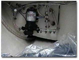 got a thorough cleaning.
All of the bug spots didn't come clean...so the jib now has some
character.
got a thorough cleaning.
All of the bug spots didn't come clean...so the jib now has some
character.
An interesting note here is that Art considers one of R&R’s best upgrades to be the blaster pump. A 15-foot hose is coiled just inside the galley cabinet door and pulls out easily to reach any spot on the boat. It is used to fill the sink or teakettle, to rinse dishes, decks, or mess from hauling the anchor, and more. At home I use it to rinse the scum line after loading the boat on trailer. Additional advantages are that it promotes greater use of the fresh water tanks, keeping them fresh and provides an easy method of draining and filling the fresh water tanks. It is one of those things that once equipped, is used a lot.
Part 4 – A Rock Leaps From the Bottom and Bites the Keel
During this slow run, we added auxiliary power and after a short time the Honda 8 quit for the first time ever. A check of the vent proved it was open. Backing out the bleed off screw bleeds the float bowl and the motor starts up next pull. Guess it was an accumulation of water. If it had been depended on the previous afternoon at East Grant Island and failed, it could have been very dicey.
Entering the bay at Three Sisters there is a private green buoy toward the left center of the channel. Staying perhaps 20 feet clear to the right, R&R’s centerboard contacts a rock in 12 feet of water. It must be a tall thin rock as the sounder doesn’t emit its loud warning when 10 feet or less water is reached. Evidently we were supposed to hug the green marker. There is an interesting looking marina at Three Sisters with what looks to be an elaborate system of rails and a large A frame lift. The bay is provided with many moorings but we move off to the side and anchor in 10 ft of water. As it is early and has been an easy day, we decide to fix the keel cable and inspect any damage to the centerboard.
Deciding that I may be in the water for an extended time in these frigid waters, the wet suit from my catamaran days is dug out. This proves to be a blessing and a curse as it is difficult to get under water while wearing it. A quick examination confirms my suspicions about the cable; somehow the new cable had slipped off the forward turning sheave where it had been routed while on the trailer and I hadn’t noticed when connecting it to the centerboard during my last outing in Texas.
Deciding to unhook on the inside of the boat rather than at the center board with the possibility of losing the pin, the cable is dropped out of the tube and passed over the forward turning sheave and back to the turning ball but I am too buoyant, making it impossible to hold position to stuff the cable up the tube. A line is passed around the boat to give a handhold and the next try is successful.
The dingy is removed from the forward V berth locker and set up across the coamings. The motor is swapped for exploring. With three of us aboard however...it will not plane so our wanderings are short. Later, Matt sets out exploring on his own and as he chooses to do this each time opportunity exist, it must be something he enjoys.
The evening meal was hamburgers and pasta salad. Breakfast the following morning was pancakes. I love pancakes and out in the open while camping or sailing, they are fantastic. After breakfast, Art and I visit the marina in the dingy to top up our two gas cans and had a great chat with the operator. He is English, but has been in Canada for many years, several of, at the marina as caretaker. He confessed that his wife hadn't shared the enjoyment of isolation as he did and had stayed several months each winter visiting children and had passed away a year back. Some of his children live in the Caribbean and he confessed some enjoyment of his first visit away from the Ontario winter last season and plans to go again this year. The marina is a source of pride and we were treated to a very interesting history discourse.
Part 5 - Don’t Distract The Helmsman
Thirty years ago, uranium mines nearby had brought many employees who enjoyed sailing in the summer season. The mines provided hardware resources for this rather unusual marina. which I apologize for not having pictures but hope that I can describe adequately. The marina was built with mining technology and equipment. It consisted of a set of rails that were fastened to cross ties and extended out into the bay. A barge-rail car was used to travel this track and retrieve the boats to a tall A frame fixed lift that straddled the track. The track continued past the storage yards to a transfer track that ran perpendicular to the ramp track. A dozen or more siding tracks were parallel to the ramp track. These could accommodate several boats depending on the length. Most of these came back toward the bay do to the hill behind the marina. Each boat had a rail car. Some of these were simply a set of rail axles and wheels secured to the boats trailer. Those for larger boats were more involved. A dragline winch was used to retrieve a boat and car from the track into the water. The same winch could be used to operate the A frame hoist if dropping a mast. The very tall A frame lift would allow most mast to clear beneath and the cradle car would then proceed to the transfer car and track carrying the boat to whichever siding desired. The cradle car would then roll off the transfer car to the siding track for wintering.
The floating docks were sectioned and floated above a rail barge that could be either submerged to follow the track or ballasted to float. Some years when the ice was in good condition, the floating docks were hauled out on the ice prior to it melting. All boats were moored with dockage only for fuel and loading of equipment. There were siding tracks on both sides of the ramp track. The operator said the system worked very well with only a few minor inconveniences but that usually, no more than two boats would need moving in order to access any boat in the yard for launch or in the case of a sale.
Some may be interested in
the clubs fees, which are 400 dollars Canadian for a year for mooring and
storage. However, because the
marina has one employee, volunteer labor is needed and paid at the rate of
20 dollars per hour for 10 hours of labor credited towards the following
years fees. So, it would be
possible to moor at Three Sisters for around 200 dollars (Canadian)
annually. The gentlemen
explained that a very nice  retirement community had sprung up near
by...for those interested in either summer residence in the cool climate
of northern Ontario, or year around if one likes to snow mobile and enjoy
the northern winters.
retirement community had sprung up near
by...for those interested in either summer residence in the cool climate
of northern Ontario, or year around if one likes to snow mobile and enjoy
the northern winters.
Hugging close to the green marker of course, we departed Three Sisters with a routing through the Whalesback Channel toward Spanish. During this channel passage we met C25 / 3743 heading west and exchanged ahoys and getting a picture. South of Spanish are many marshes but further southeast is Boomcamp Bay. This is a really nice bay and even with west winds there are a few places to tuck. We had it to a few mosquitoes and ourselves. Matt spent a good bit of time exploring off in the dingy. Preparing for supper I extracted a package of Girl Scout cookies from our pantry box. We each had a couple after the meal and it was agreed that because of the chocolate, they would be better after being chilled. Matt put them in the cooler.
Art and I elected to go
to Spanish in the dingy and inspect the marina.
Access to the marina is via a long channel, which is straight and
well marked. This marina is
really nice. On past the
marina and around the bend is the community of  Spanish.
Continuing past are several additional channels and probably the
entrance to the river. One
channel leads back to Boomcamp Bay. Back
at the boat, its time to try one of those chilled chocolate
cookies...what.... where did the go?
Matt starts signing...even I can figure this out.
Lets see, casting a fishing rod.... fish swimming.... bait on a
hook...Oh.... the cookies were used for bait and are all gone.
Uh huh....
Spanish.
Continuing past are several additional channels and probably the
entrance to the river. One
channel leads back to Boomcamp Bay. Back
at the boat, its time to try one of those chilled chocolate
cookies...what.... where did the go?
Matt starts signing...even I can figure this out.
Lets see, casting a fishing rod.... fish swimming.... bait on a
hook...Oh.... the cookies were used for bait and are all gone.
Uh huh....
Only a stones throw over
the ridge from Porter Point where we anchored for the night, is another
anchorage to the south on the other side of a ridge.
This Area of the North Channel has many very nice anchorages.
At Little Detroit we discover the very small channel but adequate
depth to enter McBean Channel which leads southeast towards Little
Current. Little Current is
not on our route for this year however, instead we will bear south and
ultimately plan to anchor at Clapperton Bay on the south coast of
Clapperton Island. This south
run in a light easterly wind gives us an opportunity to fly the drifter
again. Rounding the
southeast corner of Clapperton in the early afternoon we decide we have
extra 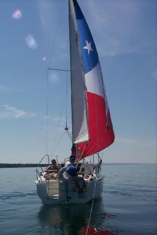 time and decide to alter our plans, as we are low on ice and head
for Gore Bay. The
crossing of Mudge and Julia bays is the only hot weather of the trip and
done with little wind with the cabin fan turned on for the first and only
time during the cruise. Down
below we escape the sun and play cards with the autohelm in control.
In the afternoon during one of my horizon checks for traffic a
fresh cool breeze from the south has stirred and sail is hoisted for the
remainder of the course to Gore bay.
time and decide to alter our plans, as we are low on ice and head
for Gore Bay. The
crossing of Mudge and Julia bays is the only hot weather of the trip and
done with little wind with the cabin fan turned on for the first and only
time during the cruise. Down
below we escape the sun and play cards with the autohelm in control.
In the afternoon during one of my horizon checks for traffic a
fresh cool breeze from the south has stirred and sail is hoisted for the
remainder of the course to Gore bay.
Close to the bay, Art is at the helm and Matt and I get into a discussion via a written dialog on paper. It is about some of the intrinsic differences between knots and miles per hour. As usual.... he has drawn some rather good conclusions of how he thinks it is and desires confirmation. About this time Art joins in and starts signing some to him to further the discussion and all of a sudden the sounder goes off and Matt simultaneously pipes up with appropriate attention getting sounds to warn us off the east side of the bay. Art has cut the point a little close and found some shallow water. Matt doesn't miss much and his warning is certainly appreciated. Matt attempts to ride his dad a bit for not watching, and dad rebuffs by explains that if he hadn't been answering his distracting questions at the time... I'm just glad that the sounder and Matt caught it in time to head off.
At Gore Bay marina the boat is serviced and anchorage taken followed by rowing the dingy to the dock for a walk into town for supplies. Matt’s turn to cover the expenses and he uses his credit card and we have an interesting walk back to the boat with Art signing that Canadian currency differences will be reflected when he gets the credit card billing. Upon approaching the dinghy, a small floatplane heads out into the bay turning around quickly and powers up for take off and is airborne in a short distance and climbs out over the town and ridge to the south. An afternoon swim is refreshing as it was hot for the first time during the afternoon. The evening meal was red beans and rice with polish sausage. Matt doesn't eat beans so he cooked some macaroni and cheese to eat with his sausage.
In the morning, we returned to the marina docks as we had forgotten to take on fresh water and while there did a little shopping. In my pocket for each of the kids is a Toony ...a two-dollar Canadian coin, distinctive because it has an insert coin pressed into an outer coin. With a brisk south by southwest wind, we sail smartly out of the bay and head west at a good speed for a very nice days sail and cover the entire distance to Robinson Bay on Cockburn Island with power only used to enter the bay. The wind has been there all day but is fluky with lifts and headers and several reef sets and shakeouts.
Into Robinson Bay, we join one other boat at the south end that appears to be on a mooring but occupied. Robinson Bay is vulnerable to the north and Canadian weather forecasts generally offer less rather than more in forecasting wind directions. Today has been generally SSW and typically diminishes as dusk with the usual amount to keep ventilation into the forward hatch. This is one of the nice things about Great Lakes sailing, seldom does it get still and hot in the cabin at anchor and generally an anchorage is more comfortable than a marina as the boat careens into the wind allowing the hatch to focus air down and thru the cabin.
Part 6 – Leaving In The Night
 An afternoon swim is
taken...though not enjoyed. The
water here is cold, and where normally Art or I choose to work our way
down the swim latter...it is difficult to overcome the cold and find nerve
to submerse. Only one
remedy.... climb back aboard and jump.
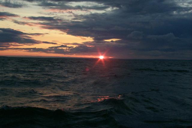
Art chooses the same course and the swim is shorter than usual due
to the cold water. The sky is clear and we enjoy a pretty sunset as we play
cards. It has been a rowdy
game and great fun. Matt had
lost his touch in recent games but this evening has once again established
his dominance. A Canadian broadcast is found of a youth fiddling contest
which Art enjoys as I fall asleep. During
nature call prior to bedding down, a well-lighted freighter passes east
just outside the bay and we wonder where it has come from and is bound to.
An afternoon swim is
taken...though not enjoyed. The
water here is cold, and where normally Art or I choose to work our way
down the swim latter...it is difficult to overcome the cold and find nerve
to submerse. Only one
remedy.... climb back aboard and jump.
Art chooses the same course and the swim is shorter than usual due
to the cold water. The sky is clear and we enjoy a pretty sunset as we play
cards. It has been a rowdy
game and great fun. Matt had
lost his touch in recent games but this evening has once again established
his dominance. A Canadian broadcast is found of a youth fiddling contest
which Art enjoys as I fall asleep. During
nature call prior to bedding down, a well-lighted freighter passes east
just outside the bay and we wonder where it has come from and is bound to.
 At 1:30 am, our home
begins to bounce. I have
always preferred the V berth because it has much better ventilation, which
can be easily adjusted by the forward hatch without getting out of my bag.
It is also easy to poke from the hatch opening to check for anchor
drag or weather conditions. However,
the V berth grows uncomfortable during chop.
At first, I did the normal thing and denied the motion.... just a
temporary thing. It wasn't
all that unpleasant but within twenty minutes becomes rude.
Opening the hatch to determine if it was a thunderhead stirring
things up, a clear sky is discovered with a full moon off to the south so
bright that it is difficult to see the stars.
At 1:30 am, our home
begins to bounce. I have
always preferred the V berth because it has much better ventilation, which
can be easily adjusted by the forward hatch without getting out of my bag.
It is also easy to poke from the hatch opening to check for anchor
drag or weather conditions. However,
the V berth grows uncomfortable during chop.
At first, I did the normal thing and denied the motion.... just a
temporary thing. It wasn't
all that unpleasant but within twenty minutes becomes rude.
Opening the hatch to determine if it was a thunderhead stirring
things up, a clear sky is discovered with a full moon off to the south so
bright that it is difficult to see the stars.
The wind has shifted towards the north and freshened, kicking chop into the bay and tossing me against the sides of the hull with sleep now impossible. Checking the cockpit, it is better but not great and I am now wide-awake. We decide to bug out under the full moon rather than pitch at anchor. The plan was to head west if winds were favorable, to the Les Chenneaux Islands; an early start would not hurt. We had gained a day, and wanted to add the islands to our cruise for Matt to see. The shift of the wind to the North West wasn't good but if it continued to clock north.... it might yet provide a west course.
The full moon provides more than adequate light to easily sail by. Anchor is hauled for a 2 am departure south thru the Mississagi Strait. The freighter we had seen earlier had returned to a position to the north of the bay and is lit up almost like a cruise ship. It evidently was waiting to port at the mining docks in the strait but wished to stay out of the channel. South of the strait, I checked the possibility of a west course and determined 240 degrees was the closest course to weather, not good enough to head fifty miles west. South by southwest is Lower Michigan’s Presque Isle harbor, and the waypoint is selected on the gps and the track button pushed on the autopilot. With sails trimmed to the broad reach, the boat moves well at 5 ˝ knots in moderate air almost directly toward the shimmering reflection of the moon.
The night sailing with a full moon was absolutely fantastic. This is my first night sail on a course toward a full moon on a large body of water and the scene is amazing. There is just enough wave height to pitch the boat fore and aft. Watches are traded the remainder of the night with each getting additional sleep in the now gentle movement. Matt awoke about 6:30 and after some breakfast took the watch until I woke again at 8:30. It was now possible that we were far enough south to catch NOAA weather transmissions from Alpena that cover the north Lower Peninsula. The forecast caught our attention. The remainder of the day was good but thunderstorms were due by midnight and would continue thru the next day with a chance of some of them producing severe weather. The marine forecast called for winds tomorrow of 15-25 building to 30 knots by afternoon from the Northwest. This would mean the possibility of six-foot seas. Six foot is not a problem on the ocean, but with the short swell period of the Great Lakes, can provide a wild ride. Winds over 25 knots combined with sever storm warnings.... meant our weather window was closing.
With the probability that making Presque Isle will weather us in for a day, and with the weather window to sail down the coast open until midnight I hit the Goto button on the GPS, call up Harrisville and read the ETA to place us there by 7:30 PM by averaging 5 knots. This decision makes this leg equal to the 90 miles of the previous longest passage last year as we crossed from South Bay on Manitoulin Island to Harrisville. Unfortunately conditions are different. Last year that entire leg was under sail with some very good boat speeds of 7.4 knots sustained for more than two hours.
Part 7 – Marsh Grass and Cormorants
Night and morning winds have driven us south at 5 knots but around mid day the forecasted onshore breezes develop and the wind clocks from the northwest around to the east. Inadequately strong to maintain our needed 5 knots, we motor sail the rest of the way. After lunch I nap again and when waking climb into the cockpit from below as we make the point off Thunder Bay Island. A glance westward towards Michigan’s shoreline notes the distinctive point and that we are standing out the appropriate distance. All looks well until looking eastward I see a very large patch of marsh grass. A quick glance at the depth sounder shows plenty of water. What’s up? I quickly inquire if we were on course to the waypoint and get a nod. I commented that something had to be wrong as we were inside of the marsh grass and even as I said it.... I couldn't reconcile the grass to the depth on the sounder or the vision that we were stood out the appropriate distance from the point.
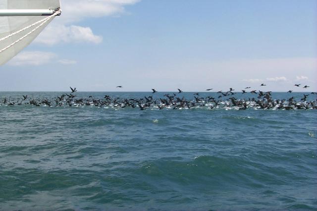 “Marsh grass, where?”
Over there and I pointed to a huge patch a half mile wide and mile
long off a couple hundred yards to the east. “That’s not grass”,
chuckled Art! What? My sleepy eyes look again; he had my attention, if its
not grass then what was it? Damn,
a closer look confirmed that I had mistaken this huge flock of Cormorants
for marsh grass. They were so
thick and far enough off to be difficult to see clearly.
These birds are plentiful on the Great Lakes now but this was my
first sighting of such a large roosting.
“Marsh grass, where?”
Over there and I pointed to a huge patch a half mile wide and mile
long off a couple hundred yards to the east. “That’s not grass”,
chuckled Art! What? My sleepy eyes look again; he had my attention, if its
not grass then what was it? Damn,
a closer look confirmed that I had mistaken this huge flock of Cormorants
for marsh grass. They were so
thick and far enough off to be difficult to see clearly.
These birds are plentiful on the Great Lakes now but this was my
first sighting of such a large roosting.
Ten days sailing time had been allowed for this cruise with it shortened to eight but many of them had been long days and the entire course planned had been covered. After arriving Harrisville, customs was called to recheck back into states and Art gets transportation to his brothers for the truck and trailer. It just turned dark when the boat was buttoned on the trailer.
The following day turned out to be rather nice with a good northwest breeze which would have provided good sailing conditions for us had we put into Presque Isle and sailed down the coast the next day. The morning was spent preparing the boat for the return to Texas. The scum line was cleaned, the outboard moved to the tongue mount, the logs brought up to date and all Art and Matt’s gear unloaded. In the afternoon, Art and I visited some friends, and later I visited an old school friend in his hay field. After supper, Art and I visit with my best friend from high school for several hours and talk about the next cruise, he is interested.
Always eager it seems to get home after the sailing is over, I decided to head back a day early. heading west across the state to avoid road construction encountered on the up trip. Within an hour after leaving, a gas stop is made where I dicover that the weather has turned nasty with temperatures dropping to around 50 deg with heavy overcast skies and high gusty northwest winds. This is the weather that was warned to come but had stalled for 36 hours. Had we put into Presque Isle and held the next day…. these would be our conditions. It is rarely true, but this morning I am happy to be sailing down the interstate rather than Lake Huron.
Three-hundred eighty
miles were covered on our 2000 cruise and adding these to the previous two
years put R&R over the 1,000 mark for cruising North Huron, North
Channel and Georgian Bay waters over the last three seasons. Many modifications and added equipment
have made it into a very comfortable boat for the length of passages that
it has experienced. This
year, the Texas flag flew at the top of the mast and both the Catalina
25/250 Association and Trailer Sailor burgees on the starboard spreader
halyard. My Catalina 250
water ballast continues to perform the task of a trailer sailor with adequate
space and amenities for cruising and enough savvy to handle the Great
Lakes. The boats name implies
Rest and Relaxation which it provides 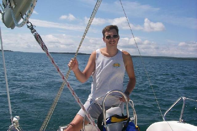 in some ways, but it in fact was
named after two of my favorite heroes….Two Richards…one my father and
the other my grandfather…..both good men, and so it goes is this boat.
in some ways, but it in fact was
named after two of my favorite heroes….Two Richards…one my father and
the other my grandfather…..both good men, and so it goes is this boat.
Tristan Jones wrote, "The most important decision a captain of a small boat makes is who he takes sailing with him." Again, Art was a pleasure to sail with as always. Matt was great, taking very good care of his personal things and carrying more than his share of the onboard task. He learns very quickly, is fun to be around, and has a quick wit and good sense of humor. I am glad to have sailed with him and hope he enjoyed himself. Since his loss of hearing at age 3, it has never appeared that he considers himself restricted in abilities. He certainly has a great feel for wind and sail and seems to be blessed with the malady known as ”a quest for adventure.”
For any stowaways who read and enjoy this or last years story telling, I hope that your dreams come true as mine have, as it was my childhood dream to sail these waters. It then is my prayer that you find your moment in time.
Arlyn Stewart
C250 w/b "R&R"
Submitted: March 31, 2001