|
|
|
|
|
|
|
|
|
|
|
|
|
|
|
|
|
|
|
|
|
|
|
|
|
|
|
|
|
|
|
|
|
|
|
|
|
|
|
|
|
|
|
|
|
|
|
|
|

Chartplotting with OziExplorer
By Arlyn Stewart
 The
main screen depicts a chart that was stitched together from an Eastern and
Western chart. The waypoints and routes from this years cruise are shown.
The colors for the tracks can be selected.
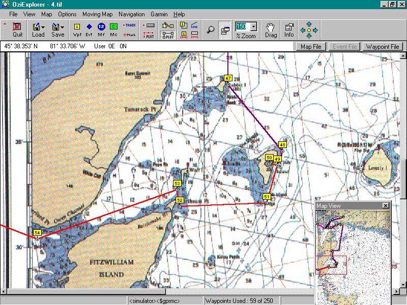
The
main screen depicts a chart that was stitched together from an Eastern and
Western chart. The waypoints and routes from this years cruise are shown.
The colors for the tracks can be selected.
 Another
chart has been selected of the Georgian
bay. The box on the lower right depicts the map view area
of the larger chart that has been selected. It is a drag box to quickly
reposition the focus area on another
portion of the chart. Charts can quickly be resized from .25 to 400
percent.
Another
chart has been selected of the Georgian
bay. The box on the lower right depicts the map view area
of the larger chart that has been selected. It is a drag box to quickly
reposition the focus area on another
portion of the chart. Charts can quickly be resized from .25 to 400
percent.
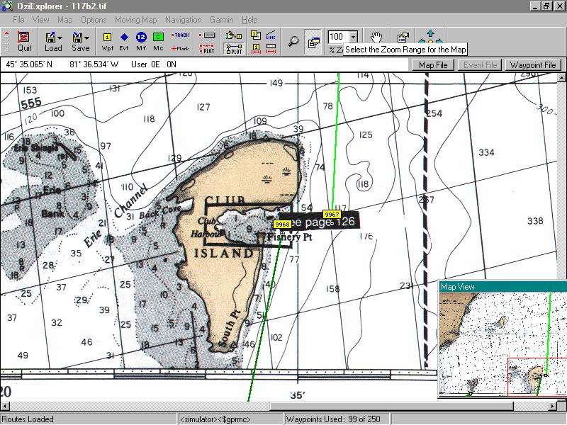
If using the moving map display, a chart
stays centered on the boat mark and as soon as the boat enters the Club
Harbor chart area, the screen will auto switch to the chart below.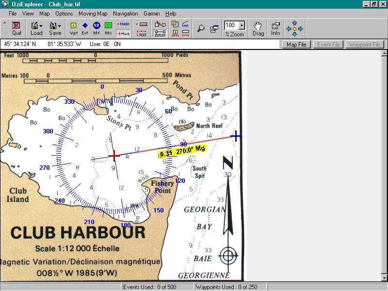
I have placed a compass rose over the anchorage so that a course can be both visual and read from a mark that is placed outside of the harbor. Note the distance displayed to the mark of .29 miles as well as the course info. All courses can be set up in magnetic or true. The compass rose as well can be set up either way. OziExplorer is a well-done program for those who can do without tides as a part of their chart plotting program.
Chart plotting With OziExplorer
Last year I had used a freeware program called SeaClear to assist in preparing my waypoints and routes for my summer cruise of 310 miles in Northern Lake Huron waters. Last fall, some one on the Trailer Sailor board made a comment about a shareware program called OziExplorer. Taking a look at it, I decided to register and by the next day had received the unlock code from the author in Australia to open up the full features of the program. Its origins were to support the authors Out Back 4 wheeling, but had been adapted to support sailing. The price of this chart plotting software was sixty-five dollars, a lot less than commercial packages. After using the program to prepare for and during this summers cruise of 380 miles, I feel that this is a great program at a great price
Chartplotting can he had in two forms, a dedicated CartographicGPS or the combination of a computer interfaced with a GPS. This latter method is the one I chose to use and will provide some rudimentary outline of how it works. Moving map is a term that indicates that when interfaced with a gps, the data from the gps provides the program with a fix that is marked on the chart. The chart moves so that the fix remains in the middle until the chart reaches a border and then the fix mark makes its way to the edge. If there is another chart beyond that edge which will show the position, the new chart will auto load and the fix continue to be displayed. If the fix enters a higher resolution chart border, then that chart will be chosen. For example, if entering a channel and there is a detailed chart for the channel, the program will automatically switch to that chart when it reaches it’s border.
The interfacing cable is a serial connection and easy to connect to most GPS units and computers. OziExplorer is coded to work with many different gps units. The charts can be from a variety of sources. Charts are now widely available on CD or can be scanned from existing paper charts. I used the latter because I already had the paper charts needed. It is important to remember that electronics are nice, but they can and do fail. Paper charts are needed for safety considerations; so if you get your charts on CD, then print them out as well.
Using my flat bed scanner, I produced the data charts and used the calibration routine within OziExplorer. This can be tedious and if a lot of charts are needed and if time is in short supply, then CD charts may be a good choice. I think as time goes on we will see CD charts at a much cheaper price than paper charts as they would be cheaper to produce, and distribute.
OziExplorer allows marking waypoints, creating routes, making notes and comments on the charts, as well as numerous other features such as dragging charts, showing route tracks, distances in any desired format, dimming the screen to preserve night vision, setting screen contrast and much more. Waypoints, routes, and other data can be saved, transmitted to gps or received from a gps. A computer on your boat is not a necessity to enjoying OziExplorer, as waypoints and routes can be created at home and imported to your gps saving a lot of time and providing very good accuracy. Manually programming in 130 waypoints and eight routes for an eight day cruise into your gps would take a long time of button punching. With a chart plotting program, you just click on where you want waypoints set, place these in a route or routes and upload to gps.
The big disadvantage of computer chartplotting is that you don’t have the moving map in the cockpit with you. There are now some gps units that allow uploading maps to them from a computer. These units would be great. In my opinion they would make the micro chart Cartographic gps less attractive. Cockpit chart plotting is not a necessary tool for many of us. Other techniques that don’t require extra cost can be taken advantage of. Waypoints and the important cross track error between them can be very effective in keep the boat where it’s safe. Most gps units offer a screen that will map programmed waypoints at various distance resolutions. Newer units allow marking with various symbols so, in effect, it is now possible to make your own chart of an often used area with OziExplorer and upload to a standard gps.
Here is how. Use a flat bed scanner to get a chart of your harbor for example or use a blank grid. Calibrate it. This may require taking some positions and using them. Trace the shoreline with a series of chosen waypoint symbol. If using a blank grid, import the track of a motor around the inside of your harbor and then place waypoints around that track. Now Place the navigation aids with other symbols, etc. Upload to your gps.
To give an idea as to the functionality of OziExplorer, here is an example from last summer’s trip. Using charts from the Richardson Chart book, I scanned the ones for my intended cruising water using my flat bed scanner. These were imported to the program and calibrated, meaning that coordinates were defined. In one instance I decided to see just how well the program worked so we monitored the moving map location of the boat on the screen as we entered an anchorage on Club Island, in the Georgian Bay. When approaching the island the smaller chart of the island anchorage automatically came onscreen. We visually entered the bay while also observing the screen to see if the boat marker seemed to be where we actually were. Without question, we could have entered a small bay on a small island in fog and dropped the hook, having never been there before. I wouldn’t have done it, but it was proven that it would have been successful and on the first time that the possibility was explored. I realize there are those who rely upon their dedicated chart plotters and radar to do this, but this is a program where I scanned the charts and calibrated them and the results were very accurate.
I recently downloaded another chart plotting software from a Dutch author and am looking at it. If your sailing includes very many waypoints, then a chart plotting software program can be a big help and a lot of fun. Prices are right with some at no cost and a very powerful OziExplorer for a good bit less than $100. That’s it! Enjoy OziExplorer or whatever program works for you, and remember that electronics can go dead, so if you need charts for safety reasons, then carry paper charts on board along with your GPS and know how to use them.
The route editor provides a simple tool for
arranging waypoints into a specific route or routes. Select
a route and add waypoints from the available list.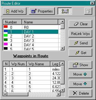
This chart of the Kemah, Texas area has
been brought into the calibration screen.
Here can be seen the degree of setup
options available.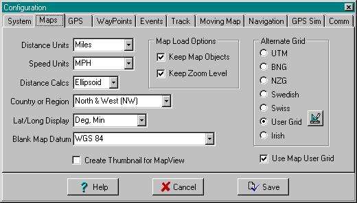
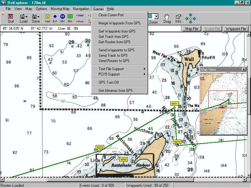 This
screen save shows the drop down gps interface window and the power the
program has to interface with the gps unit. Also shown on the chart
is the track near Fitzwilliam Island. Note the Wall Island Channel and the
two feet deep shoals. There were no aids to navigation marking those
shoals. Sticking with the waypoints and watching the cross track error was
important, as well as confirming location with depth. Levels in Great
Lakes this last season where only Ľ meter above datum. Also of interest
was we made the passage through the channel completely under sail with the
wind out of the Northwest. We close hauled to 9970, tacked on port and
after making 9971 we went to starboard reach. Actually we made some leeway
to the starboard of 9971 and made our tack a little early. It is easy to
note that a direct course wasn’t an option.
This
screen save shows the drop down gps interface window and the power the
program has to interface with the gps unit. Also shown on the chart
is the track near Fitzwilliam Island. Note the Wall Island Channel and the
two feet deep shoals. There were no aids to navigation marking those
shoals. Sticking with the waypoints and watching the cross track error was
important, as well as confirming location with depth. Levels in Great
Lakes this last season where only Ľ meter above datum. Also of interest
was we made the passage through the channel completely under sail with the
wind out of the Northwest. We close hauled to 9970, tacked on port and
after making 9971 we went to starboard reach. Actually we made some leeway
to the starboard of 9971 and made our tack a little early. It is easy to
note that a direct course wasn’t an option.
Arlyn Stewart
C250 w/b "R&R"
aa5by@cox-internet.com
Submitted: September 13, 1999