Catalina - Capri - 25s International Assocaition Logo(2006)  
Assn Members Area · Join
Association Forum
Association Forum
Home | Profile | Register | Active Topics | Forum Users | Search | FAQ
Username:
Password:
Save Password
Forgot your Password?

 All Forums
 Catalina/Capri 25/250 Sailor's Forums
 General Sailing Forum
 Google's Navigational Aids to Sailing
 New Topic  Topic Locked
 Printer Friendly
Author Previous Topic Topic Next Topic  

Unsinkable2
Captain

Member Avatar

USA
273 Posts

Initially Posted - 10/07/2008 :  14:25:34  Show Profile  Visit Unsinkable2's Homepage
I was out sailing a few weeks ago under a full moon and 10 knot winds. Beautiful night for sailing. And then the winds kicked up, clouds covered the moon, and the waves started getting a little uncomfortable. I couldn't see anything. And the wave/wind combination was so strong that I couldn't leave the cockpit to go below for my spotlight.

I knew there was an old marina about 2 miles south, and even had it marked on my GPS. No problem, I decided I better spend the night there rather than try and make it to home port that night.

I couldn't see anything, the night was completely black under the clouds. The "marina" was used for launching small trailered fishing boats, and did not have any working beacons or useful lights.

By the GPS, I was headed straight into the opening between the jettys. But as I got closer, the sound of waves smashing into the rocks all around me told me that my coordinates were perhaps off by a bit. I was nowhere near the opening.

I moved away from the shore to figure things out. The waves were too big to spend the night at anchor, there were no boats in the area, and I was too tired by then to try and make it to another safe harbor.

And then it dawned on me. I pulled out my cell phone (an AT&T Tilt) which had a GPS on it. The other thing it has is an interface to google satellite imagery. Within a minute, it had acquired, and accessed the cell tower to download the google satellite image.

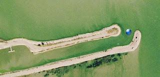
The great thing about the satellite image was that it had been taken in the daytime, so I could clearly see the jetty, with my position superimposed on the image. I motored back towards the jetty, staring desperately at my cell phone screen and listening for the break in the crashing waves. After a minute, there it was!

The jetty opening was only about 15 feet wide, there was no way I would have made it in the dark. (My GPS coordinates had been about 100' off.)

I slipped right into the little empty marina, watching the small blue dot move along the satellite image right up to the empty dock. I spent a very relaxed night listening to the waves crash against the jetty, thankful that I wasn't experiencing the sound from the other side of the wall...

This is a great emergency navigational tool, and it is probably available around most lakes and coastal cruising areas - anywhere you can get cell phone reception the phone can superimpose google's satellite photos. The best part is, AT&T charges a monthly fee for the satellite image services, OR... you can download a plugin free from google.

--Skipper of the Unsinkable2
http://blog.unsinkable2.com
1977 Catalina 25 SK/SR #246 "Unsinkable 2"
1964 Lido 14 #1878 "Tomato Sloop"

Edited by - Unsinkable2 on 10/07/2008 14:52:01

redeye
Master Marine Consultant

Members Avatar

3475 Posts

Response Posted - 10/07/2008 :  14:54:17  Show Profile
Google rocks!

Ok.. in this case you Googled off the rocks!

Can't get over how different things are.

Brave New World...


Edited by - on
Go to Top of Page

John Russell
Master Marine Consultant

Members Avatar

USA
3444 Posts

Response Posted - 10/07/2008 :  14:56:10  Show Profile
Cool! I wonder if the plug-in works with verizon? I'll have to explore.

Edited by - on
Go to Top of Page

Unsinkable2
Captain

Members Avatar

USA
273 Posts

Response Posted - 10/07/2008 :  15:58:43  Show Profile  Visit Unsinkable2's Homepage
Here's the google page with more information. The service is free from Google (you will use your data plan on your cell phone though)

http://www.google.com/mobile/default/maps/index.html

Looks like it works on just about any phone operating system:

"Google Maps for mobile works on most phones, including those that run the below platforms. You can always download Maps to your phone using your cellular connection -- just visit m.google.com/maps on your device's browser, or send yourself a text message using the button at the top of this page. Some mobile phones also support the ability to sideload Google Maps onto your phone.

* BlackBerry
* Java
* Windows Mobile (download binary)
* Symbian S60 3rd Edition (most new Nokia smartphones) (download binary)
* Palm OS (download binary)
* iPhone (pre-installed)
If you're not sure whether your phone runs one of these platforms, just try sending yourself a text message to get Maps. It will probably work!"

Edited by - on
Go to Top of Page

Steve Blackburn
Master Marine Consultant

Members Avatar

Canada
1091 Posts

Response Posted - 10/07/2008 :  16:22:58  Show Profile  Visit Steve Blackburn's Homepage
I get "Invalid phone number." Maybe because it's a Canadian phone number?

Edited by - on
Go to Top of Page

delliottg
Former Mainsheet C250 Tech Editor

Members Avatar

USA
4479 Posts

Response Posted - 10/07/2008 :  16:26:34  Show Profile  Visit delliottg's Homepage
Very cool way of getting yourself out of a nasty situation. I don't think our Sprint phones are capable of this, but I'm going to check, I know it'll do GPS.

Google does some very cool things with phones. If you text whatever you know about a company name or place address, it'll send you back what it knows with phone number, address, etc. about it. Text to GOOGL (46645). Very handy when you've left your driving instructions on the kitchen counter where you wouldn't forget them.

Edited by - on
Go to Top of Page

Unsinkable2
Captain

Members Avatar

USA
273 Posts

Response Posted - 10/07/2008 :  16:37:40  Show Profile  Visit Unsinkable2's Homepage
Yeah, cool service. And it's even better with the maps. (the maps also work without GPS, but they triangulate your position from the cell towers, so you have a higher margin of error).

Now if they could just get sailing directions in addition to driving directions: "Continue your 180 degree heading for 2 minutes, tack, then fall off onto a broad reach at 310 degrees for 14 minutes. The harbor will be on your port side..."

Edited by - on
Go to Top of Page

britinusa
Web Editor

Members Avatar

USA
5404 Posts

Response Posted - 10/07/2008 :  17:36:26  Show Profile  Visit britinusa's Homepage
Our t-mobile contract expired, so now I'm a 'free agent' and have been looking at AT&T as they have our home and office ph & dsl.

Thanks for the tip, good one!

Paul

Edited by - on
Go to Top of Page

Steve Blackburn
Master Marine Consultant

Members Avatar

Canada
1091 Posts

Response Posted - 10/07/2008 :  17:42:13  Show Profile  Visit Steve Blackburn's Homepage
This is also pretty cool. Works on iPhone (with real GPS) and iPod touch.

[url="http://www.inavx.net/"]iNavX[/url]

Edited by - on
Go to Top of Page

DaveR
Master Marine Consultant

Members Avatar

USA
2015 Posts

Response Posted - 10/07/2008 :  19:16:48  Show Profile  Visit DaveR's Homepage
I suppose anyone can get caught in a bad situation but ..........
Did you use that phone to check the weather before you went sailing And yes, a very cool tool! Thanks for the heads up.

Edited by - on
Go to Top of Page

crystal_blue
1st Mate

Members Avatar

USA
58 Posts

Response Posted - 10/07/2008 :  19:28:29  Show Profile
Mike, was this on the Great Salt Lake?

--Jim

Edited by - on
Go to Top of Page

Unsinkable2
Captain

Members Avatar

USA
273 Posts

Response Posted - 10/08/2008 :  07:46:15  Show Profile  Visit Unsinkable2's Homepage
Yes, I did check the weather, however I am finding that the forecasts over this area are more accurate for the towns to the east, and don't cover life on the water very accurately. The forecast had called for 10 mph winds and partly cloudy skies.

Here's a re-creation of what I saw on the cell phone. Note that it is zoomed out a bit so you can see the whole marina (with it's one small dock :) The blue dot marks your position on the image. Winds were from the northwest-ish (upper left of photo) and my gps coordinates put the opening somewhere along the lee shore. "Shore" is putting it kindly. It is more like the "lee-battlement-of-hull-crushing-angry-concrete-slabs Shore".


Edited by - Unsinkable2 on 10/08/2008 08:18:50
Go to Top of Page

Unsinkable2
Captain

Members Avatar

USA
273 Posts

Response Posted - 10/08/2008 :  08:20:17  Show Profile  Visit Unsinkable2's Homepage
Jim, this was on Utah Lake. The marina was the Lincoln Marina. That marina is mostly used by sportsmen going catfishing out around Bird Island.

Here is a map:


If these images are too small, click on the pics on my blog to see the full size versions:
http://blog.unsinkable2.com/2008/10/googles-navigation-aids-for-sailors.html

Edited by - Unsinkable2 on 10/08/2008 08:25:04
Go to Top of Page

crystal_blue
1st Mate

Members Avatar

USA
58 Posts

Response Posted - 10/08/2008 :  12:52:33  Show Profile
Thanks, Mike. And Dave, I can second Mike's observation--even for the towns on the Wasatch Front, my experience is that local weather reports tend to be hit-or-miss.

--Jim

Edited by - on
Go to Top of Page
  Previous Topic Topic Next Topic  
 New Topic  Topic Locked
 Printer Friendly
Jump To:
Association Forum © since 1999 Catalina Capri 25s International Association Go To Top Of Page
Powered By: Snitz Forums 2000 Version 3.4.06
Notice: The advice given on this site is based upon individual or quoted experience, yours may differ.
The Officers, Staff and members of this site only provide information based upon the concept that anyone utilizing this information does so at their own risk and holds harmless all contributors to this site.