Catalina - Capri - 25s International Assocaition Logo(2006)  
Assn Members Area · Join
Association Forum
Association Forum
Home | Profile | Register | Active Topics | Forum Users | Search | FAQ
Username:
Password:
Save Password
Forgot your Password?

 All Forums
 Catalina/Capri 25/250 Sailor's Forums
 General Sailing Forum
 Navionics app with NOAA ENC charts - free
 New Topic  Topic Locked
 Printer Friendly
Author Previous Topic Topic Next Topic  

TakeFive
Master Marine Consultant

Member Avatar

2270 Posts

Initially Posted - 07/26/2014 :  21:01:22  Show Profile
Just today I discovered that Navionics has free apps for Android and iOS that include NOAA ENC charts:

[url="http://www.navionics.com/en/document/press-release-navionics-boating-free-us-govt-charts"]Press Release - Navionics Boating with Free US Govt. Charts[/url]

It's been out for a couple months, but I had not realized it before.

Edited by - on

shnool
Former Capri-25 Tech Editor

Members Avatar

USA
1032 Posts

Response Posted - 07/27/2014 :  02:33:10  Show Profile  Visit shnool's Homepage
Is this different than the version I've been using for years, that was $10 for android/iphone, and $50 for tablets? I think that was Navionics Ocean and Lakes... I know it had all the coastal waters, used it in Oriental, and on my little puddle of a lake.. the deep topo map data was impressive.

sounds like the govt maps aren't available for android yet. But sounds like a cool addition.

Edited by - on
Go to Top of Page

Stinkpotter
Master Marine Consultant

Members Avatar

Djibouti
9017 Posts

Response Posted - 07/27/2014 :  13:39:34  Show Profile
I'm not finding the free (intro) version for iPhone--just for iPad.

Edited by - on
Go to Top of Page

TakeFive
Master Marine Consultant

Members Avatar

2270 Posts

Response Posted - 07/27/2014 :  18:27:03  Show Profile
quote:
Originally posted by shnool

Is this different than the version I've been using for years, that was $10 for android/iphone, and $50 for tablets? I think that was Navionics Ocean and Lakes... I know it had all the coastal waters, used it in Oriental, and on my little puddle of a lake.. the deep topo map data was impressive.

sounds like the govt maps aren't available for android yet. But sounds like a cool addition.


John, there's still a $10 version, but I think it has been renamed. It looks like the features are essentially the same. And if I weren't so fully vested in OpenCPN with my Bluetooth AIS/nav system, I'd give this serious consideration.

The web previews of Navionics charts for Lake Wallenpaupack are very impressive. Huge amount of detail, though as you know ~95% of the lake is just 40 ft. deep. My depth finder broke on my motorboat and I haven't even bothered to replace it because the bottom is so boring here. ("Here" because I'm vacationing on the lake this week.) But I don't go looking for fish either.

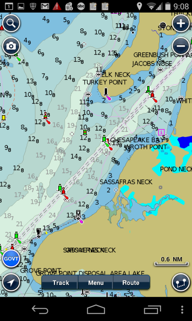
I downloaded the Android version on my phone, and it definitely has the NOAA charts. You need to zoom in a bit to see them (otherwise you just see the base map), and also allow a few seconds for a one-time download of the chart into memory (which is nicely done in the background). I do wish they would round off the depths to even feet, though. Tenths of a foot just clutters up the screen. (I complained about this to the OpenCPN developers and they changed it to my liking.)

But over all it looks like a really nice app.

https://play.google.com/store/apps/details?id=it.navionics.singleAppUsa

<center></center>

Edited by - on
Go to Top of Page

DavidBuoy
Admiral

Members Avatar

USA
707 Posts

Response Posted - 07/28/2014 :  05:03:23  Show Profile
I've been using this app for a bit now and can't believe I went with out it! Works great as a chart plotter for making trips and also as a record keeper so you can analyze the sailing characteristics in difference situations. Love it!

Edited by - on
Go to Top of Page

Voyager
Master Marine Consultant

Members Avatar

USA
5239 Posts

Response Posted - 08/02/2014 :  10:49:38  Show Profile
I downloaded the $9.99 App to my iPod touch (an iPhone OS with WiFi only, no phone or cell service). The app is very accurate, it pinpoints my location and has details from the NOAA charts that are smudges on other apps.
For example, I use the GeoGarage and iSailor apps, and while their databases are based on the same data, their rendition is not as good. Old saying goes: It ain't what you got, it's how you use it!
Nice user interface too.
Edit: As I dig in further, I notice current symbols in LongIsland Sound, and when you highlight the symbol, a (?) comes up. When you tap it, you get the +/- 24 hour tide or current chart for the area. This info is absolutely invaluable for salty sailors since a 1.7 kt current in the wrong direction can really ruin your day! If you have that info, you can plan your trip at a different part of the tide cycle or sail elsewhere that day to take better advantage of the tides. I usually do a trip plan using tide and wind data from various NOAA sources, however having close-up and real-time tide prediction data is immensely more usable for trips.
The rock and reef info is a lot more detailed than the other apps I've used, and tell me about better fishing spots!

Edited by - Voyager on 08/03/2014 09:18:40
Go to Top of Page
  Previous Topic Topic Next Topic  
 New Topic  Topic Locked
 Printer Friendly
Jump To:
Association Forum © since 1999 Catalina Capri 25s International Association Go To Top Of Page
Powered By: Snitz Forums 2000 Version 3.4.06
Notice: The advice given on this site is based upon individual or quoted experience, yours may differ.
The Officers, Staff and members of this site only provide information based upon the concept that anyone utilizing this information does so at their own risk and holds harmless all contributors to this site.